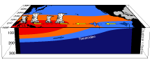

El Niño is a phenomenon in which the sea surface temperatures (SSTs) in the central and eastern tropical Pacific Ocean are warmer than average. Scientists look at the average SST in the boxes in the image below (called Niño1-4 regions) to determine whether an El Niño event is happening. The opposite of El Niño is La Niña, which occurs when SSTs are cooler than average in the same region.
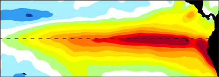
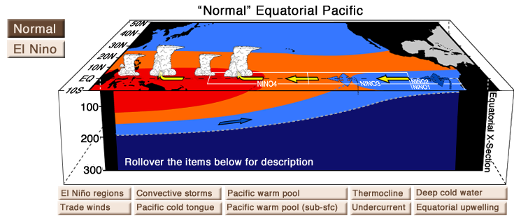 During a “normal” or average year, surface winds (called trade winds, see the yellow arrows above) blow from east to west along the equator, pushing water heated by the sun toward Indonesia in the western Pacific Ocean. All this heat leads to evaporation and convective storms above it. During El Niño, a weakening of the trade winds causes warm water to flow east into the central Pacific Ocean. Convection and storms shift to the east along with these warmer waters. During La Niña, the opposite happens: the trade winds get stronger, and convection shifts further west. To see real examples of El Niño events, go to our Varieties of El Niño page.
El Niño and La Niña evolve year-round, but the biggest changes in SSTs tend to peak during the winter in the northern hemisphere (the December-January-February months). El Niño gets its name from South American fishermen, who noticed the changing ocean temperatures around Christmas time and referred to the phenomenon as “El Niño,” the Spanish term for Christ child.
El Niño and La Niña are also referred to together as the “Southern Oscillation,” which was a term coined by Sir Gilbert Walker when he studied sea level pressures and how they oscillates between high and low in the tropical Pacific Ocean. Collectively, scientists refer to this phenomenon as ENSO, or the El Niño-Southern Oscillation. Note the word oscillation means ocean temperatures tend to oscillate back and forth, from El Niño to La Niña or neutral conditions and back again, and this occurs on a time scale of about 3-5 years.