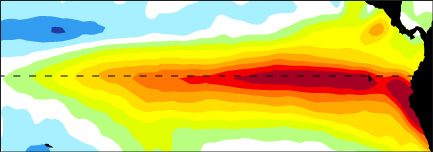

 Recall from the Global effects page that during an El Niño, sea surface temperatures in the equatorial Pacific cause changes in atmosphere above it that leads to an extension of the jet stream at upper levels (10km up). This shift, on average, tends to bring more storms to the California coast. Below, you can watch how El Niño changes the path of storms during the winter to produce a wet winter for California, and you can compare it to the dry winter of 2014.
The above movie shows satellite observations of rainfall from the Tropical Rainfall Measuring Mission (TRMM) satellite. The top two maps show winter storms during an El Niño winter (left) and a winter during the recent California drought (right), in units of millimeters per day. The bottom two maps show the accumulated rainfall for these same storms.
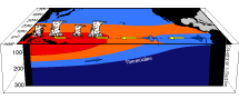
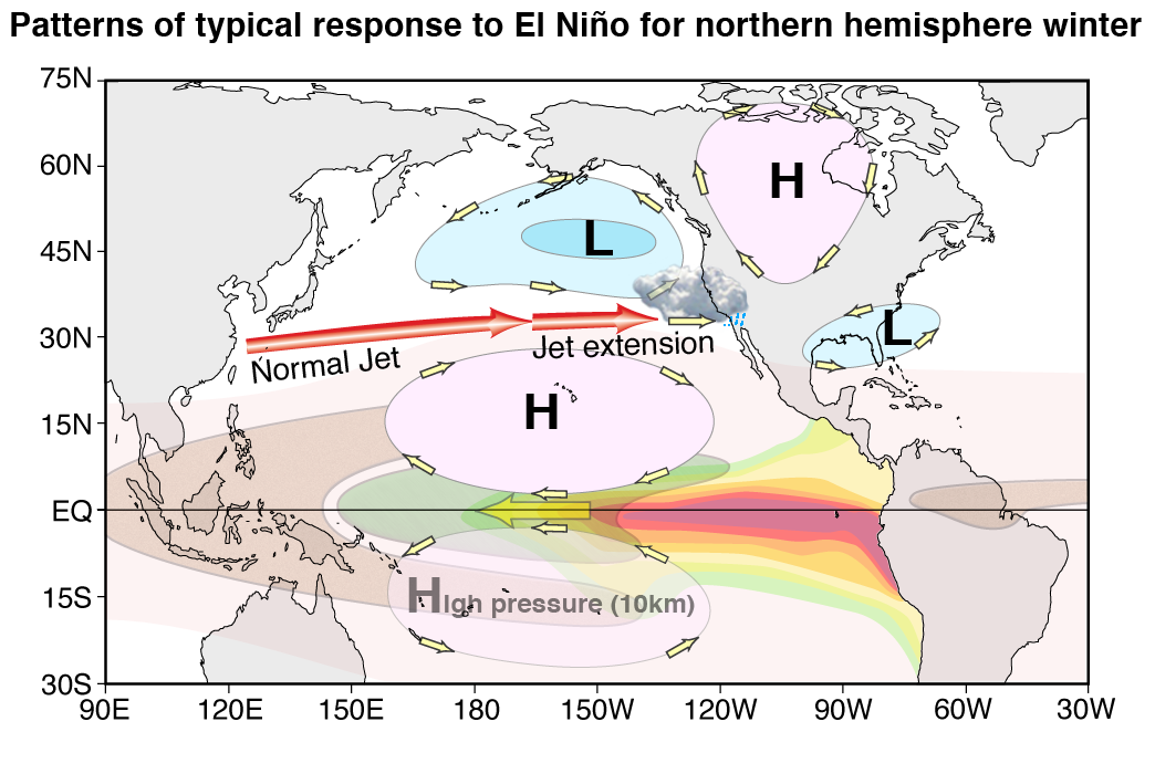
During any given year, storm systems cross the Pacific Ocean and are steered by the jet stream, which is a region of high winds at upper levels (about 10km) that help “push” or guide storms traveling east across the Pacific. This happens every winter, regardless of whether it is an El Niño winter, a La Niña winter, or neutral conditions.
During an El Niño winter, the ocean warming at the equator sets off a chain reaction that affects the atmospheric circulation at the equator, altering the jet stream by making it stronger and extending it toward the California coast. This causes more storms than normal to approach the California coast. (Otherwise, these storms would hook north and hit the Pacific Northwest, which is why Seattle and Portland tend to have such rainy winters.) To see a movie of this, make sure you check out our Global effects page.
It is important to remember that not all El Niño winters produce the same changes to the jet stream and pathways of storms. A stronger jet stream and wetter California is more likely to happen during a moderate-to-strong El Niño. For instance, the 1997/'98 El Niño was very strong, and California had higher-than-normal precipitation. In contrast, there was a weak El Niño during the 2014/'15 winter season, and California had lower-than-normal precipitation.
The current 2015/'16 El Niño is expected to be strong (comparable to that of 1997/'98). While this makes higher amounts of precipitation more likely, it is not guaranteed. This is because other things can get in the way of these storms. For example, during the 2014/'15 rainy season, a persistent area of high atmospheric pressure developed over the western U.S., diverting the jet stream north and “blocking” storms from approaching the California coast. This “blocking event” was one of the factors contributing to the recent California drought.
The 1980-2014 seasonal average for California is 19.6 inches of precipitation. The average for the 1997/'98 winter was 31.8 inches, and for the 2013/'14 winter was 11.1 inches.
What will this year bring? Only time will tell but all indications suggest a wet winter for California. Check out our Rain and accumulation page which will be updated as storms come in.