The land-surface parameterization used in QTCM1 is fully described by Zeng et al. [2]. Here we briefly describe the methodology. The scheme used is only moderately more complicated than the bucket model, and is termed Simple-Land, or simply SLand. It does not attempt to resolve accurately the diurnal solar and environmental control on photosynthesis. Thus the soil moisture and seasonal variation of radiation are the main controlling factors. The most essential features for climate simulation are the low heat capacity of the land surface, specification of land albedo for surface energy budget, and soil moisture and its consequences for surface water budget. In SLand, a single soil layer is assumed but with different depth for the energy and the water balance. Subgrid-scale variability of rainfall can significantly influence surface runoff and interception loss, and therefore evaporation. Various analytical formulations have been proposed (e.g., Entekhabi and Eagleson [23]). SLand follows essentially the same statistical approach but with choices more in line with the level of complexity of QTCM1.
Although the scheme allows many land-surface types
as long as the relevant parameter values are provided, we opt for a simple
classification in the standard version with three surface types: forest,
grass, and desert, while more surface types can be used in applications
emphasizing land-surface processes. Surface type is specified in the
array STYPE, which is of type REAL ![]() 8.
The most important surface properties include surface
albedo and field capacity which play critical roles in the energy and
the water balance, respectively.
The important surface-type dependent parameter values, including
albedo, minimum surface resistance,
field capacity, surface roughness and leaf area index,
are listed in Table 4.1 (which is identical to
Table 3 in Zeng et al. [2]).
In the standard version of QTCM1,
we use prescribed surface albedo derived from satellite observations
(Darnell et al. [22]),
while one can easily switch to using the
surface albedos linked to surface type listed in Table 4.1.
Sensitivity studies show discernible differences
at regional scales between the two methods, but these have little
impact on the global patterns. Snow hydrology is not simulated in this version,
since the atmospheric model is aimed at the tropics.
8.
The most important surface properties include surface
albedo and field capacity which play critical roles in the energy and
the water balance, respectively.
The important surface-type dependent parameter values, including
albedo, minimum surface resistance,
field capacity, surface roughness and leaf area index,
are listed in Table 4.1 (which is identical to
Table 3 in Zeng et al. [2]).
In the standard version of QTCM1,
we use prescribed surface albedo derived from satellite observations
(Darnell et al. [22]),
while one can easily switch to using the
surface albedos linked to surface type listed in Table 4.1.
Sensitivity studies show discernible differences
at regional scales between the two methods, but these have little
impact on the global patterns. Snow hydrology is not simulated in this version,
since the atmospheric model is aimed at the tropics.
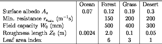
Table: Parameter values used in the land-surface model
(consolidated from BATS and SIB2).
The listed albedo values are not used in the standard version of
QTCM1; see the text in Section 4.2 for more details.