Media Gallery
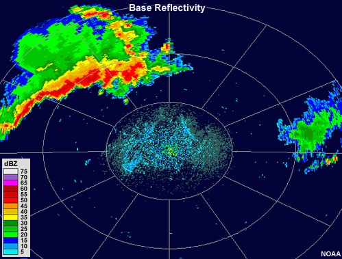
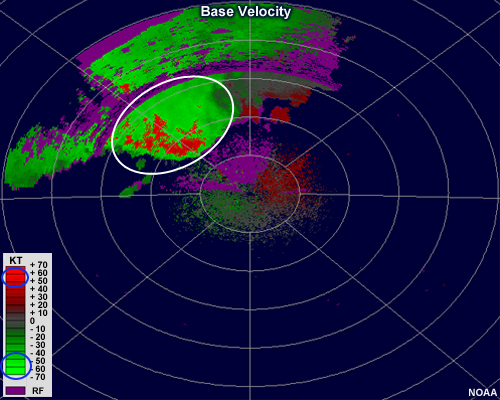
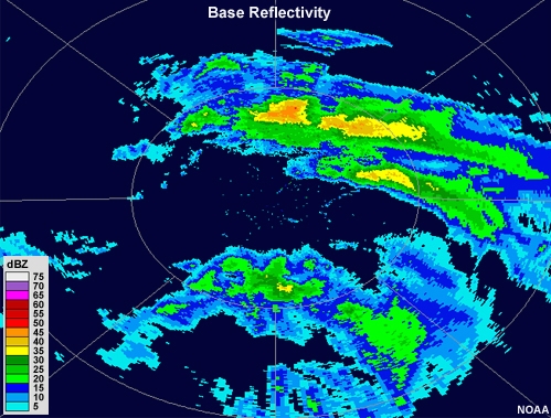
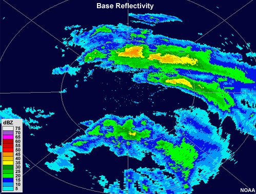
Media elements used in this module are protected by a variety of copyright licenses. Please use the "copyright terms" link associated with each item below for more information.
Description:
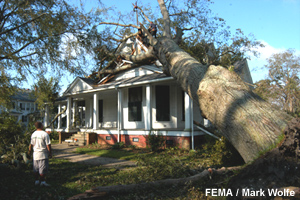
Image illustrates damage from high hurricane winds
File Name:
8467_Tree_on_house.jpg
Credits:
FEMA/Mark Wolfe
Copyright Terms:
COMET Standard Terms of Use
Description:
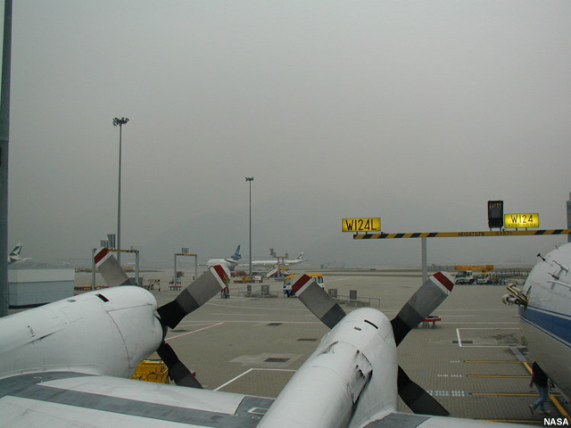
Photo from on top of parked airplane's wing showing foggy/hazy conditions filtering through the airport.
File Name:
Airport_Fog_From_Airplane_Wing.jpg
Credits:
NASA
Copyright Terms:
COMET Standard Terms of Use
Description:
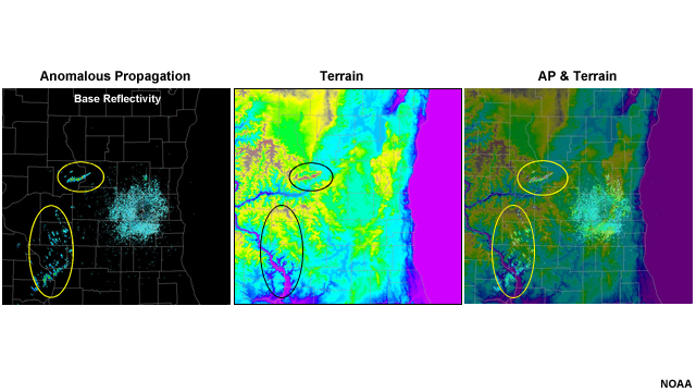
A few small, narrow areas of very low reflectivity values exist to the southwest of the radar in the left panel. In the center panel, color-shaded terrain shows local maxima in elevation in approximately the same area as the low reflectivity values. In the right panel, reflectivity is overlaid on the terrain map, and the areas of low reflectivity are aligned with the eastern sides of these protruding hills.
File Name:
AP_terrain_example.jpg
Credits:
NOAA
Copyright Terms:
COMET Standard Terms of Use
Description:
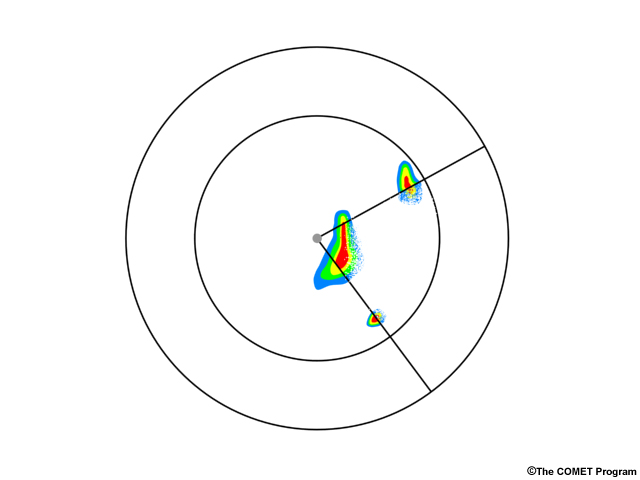
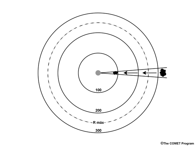
A conceptual graphic depicting how attenuation from an intense thunderstorm near the radar would cause a precipitating area farther downrange to appear less intense
File Name:
attenuation_conceptual.jpg
Credits:
© The COMET Program
Copyright Terms:
COMET Standard Terms of Use
Description:
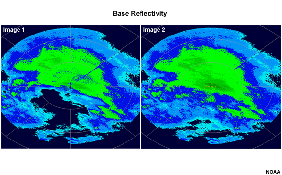
The radar reflectivity image in the left panel shows light to moderate precipitation over much of the radar range. The image on the right shows precipitation covering the same regions as that in the left panel, but also extending into areas where no precipitation existed in the left panel image.
File Name:
base_comp_comparison_question.jpg
Credits:
NOAA
Copyright Terms:
COMET Standard Terms of Use
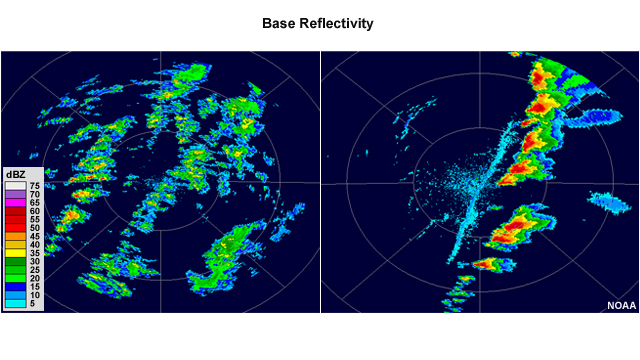
Description:
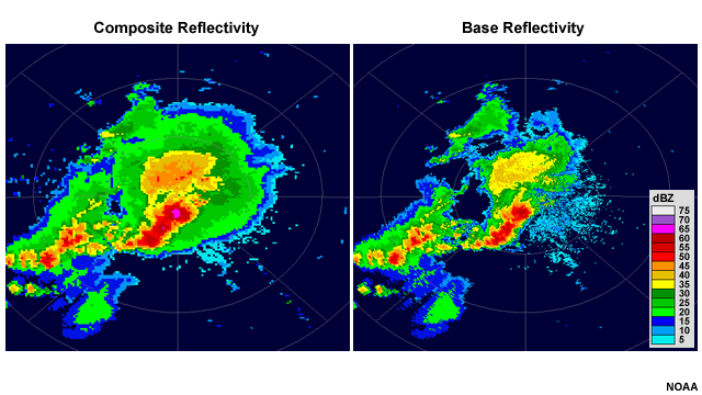
Base reflectivity and composite reflectivity comparison.
File Name:
base_composite_comparison.jpg
Credits:
NOAA
Copyright Terms:
COMET Standard Terms of Use
Description:
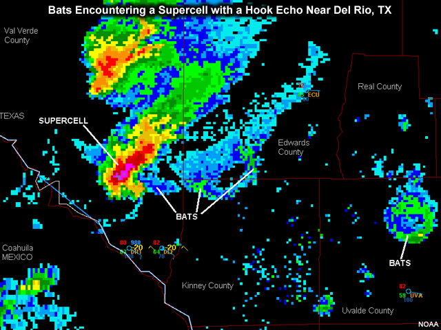
Radar image showing bats encountering a supercell with a hook echo near Del Rio, TX
File Name:
bats.jpg
Credits:
NOAA
Copyright Terms:
COMET Standard Terms of Use
Description:
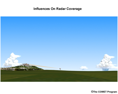
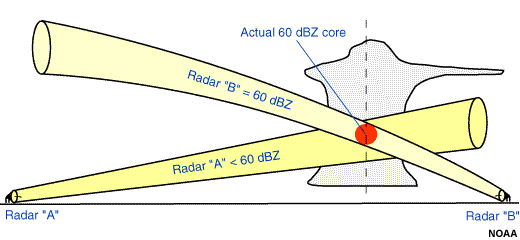
Example of radar beam blocking by terrain
File Name:
beam_blocking.jpg
Credits:
© The COMET Program
Copyright Terms:
COMET Standard Terms of Use
Description:
Example of radar beam filling differences.
File Name:
beam_filling_comparison.jpg
Credits:
NOAA
Copyright Terms:
COMET Standard Terms of Use
Description:
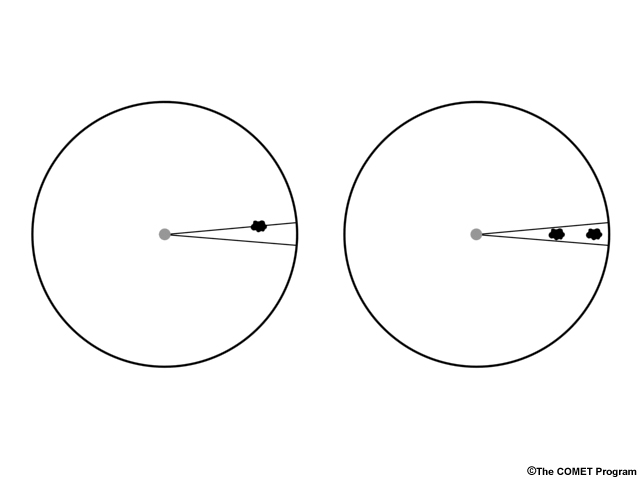
Conceptual graphic depicting a cloud filling a radar beam width
File Name:
beamfill.jpg
Credits:
© The COMET Program
Copyright Terms:
COMET Standard Terms of Use
Description:
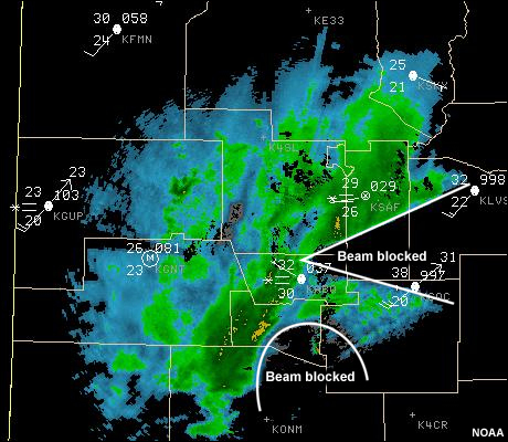
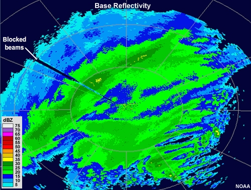
Radar image showing beam blockage
File Name:
block.jpg
Credits:
NOAA
Copyright Terms:
COMET Standard Terms of Use
Description:
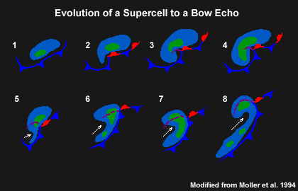
conceptual chart of stages of the evolution of a supercell to a bow echo
File Name:
bowhpev.jpg
Credits:
Modified from Moller et. al., 1994
Copyright Terms:
COMET Standard Terms of Use
Description:
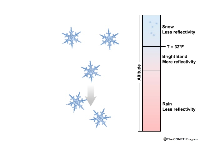
Animation showing snowflakes falling into a layer of warmer air and forming partially melted aggregates in an area where radar reflectivity is increased (the radar "Bright Band"). The flakes then melt into raindrops, creating an area where radar reflectivity is reduced.
File Name:
brightband.mp4
Credits:
© The COMET Program
Copyright Terms:
COMET Standard Terms of Use
Description:
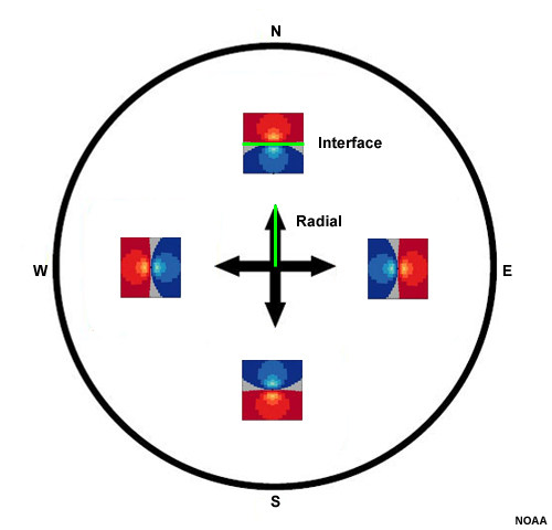
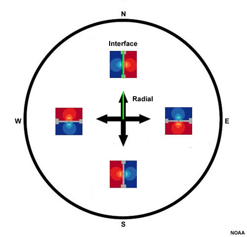
Summary image showing storm-scale divergent couplets existing in all four cardinal directions from the radar. All couplets are centered about a zero isodop that is perpendicular to the radar beam in any given direction. Couplet interfaces and radar radials are highlighted.
File Name:
brown_wood_div_summary_ann.jpg
Credits:
NOAA
Copyright Terms:
COMET Standard Terms of Use
Description:
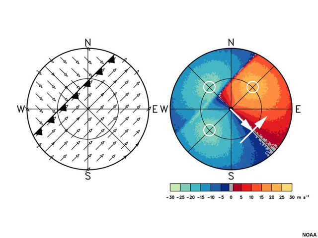
The left graphic shows velocity vectors and a front running diagonally from NE to WSW. To the north of the front, the winds are from the northwest. South of the front, they are from the southwest. The right graphic shows the accompanying idealized radial velocity image. An arrow is drawn from the center to the southeast along the radial to the first range ring. Another arrow is drawn perpendicular to that one and points to the northeast. Circles are placed at the intersection of the first range ring and the other radials.
File Name:
brown_wood_frontal_passage_1_ann.jpg
Credits:
NOAA
Copyright Terms:
COMET Standard Terms of Use
Description:
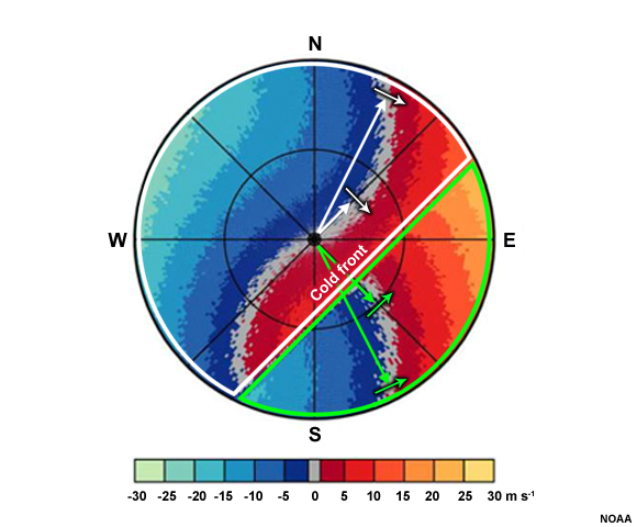
Idealized radar image in which backing winds (turning counterclockwise with height) are occurring in the upper two-thirds of the image outlined in white\, while the southeast portion of the image (outlined in green) shows winds that appear to be veering (turning clockwise with height).
File Name:
brown_wood_frontal_passage_3_ann.jpg
Credits:
NOAA
Copyright Terms:
COMET Standard Terms of Use
Description:
An idealized radial velocity image showing that maximum or minimum contain colors from the opposite wind direction (outlined in white) when the radar samples strong jets or tropical cyclones.
File Name:
brown_wood_jet_veering_aliased.jpg
Credits:
NOAA
Copyright Terms:
COMET Standard Terms of Use
Description:
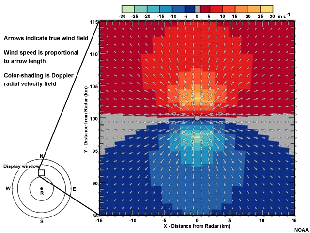
The left side of the graphic shows velocity vectors within a 30 by 30 kilometer square located 100 kilometers north of the radar. The right side shows radial velocities over the square. The arrows show strong divergence away from the center of the square. A zero isodop runs east-to-west and bisects the square. Outbound velocities in red exist to the north of the bisection, with closed isodops surrounding a maximum that lies about 3 kilometers to the north of the square's center. Inbound velocities in blue exist to the south of the bisection, with closed isodops surrounding a minimum that lies about 3 kilometers to the sorth of the square's center.
File Name:
brown_wood_pure_divergence.jpg
Credits:
NOAA
Copyright Terms:
COMET Standard Terms of Use
Description:
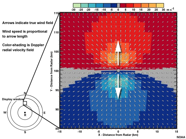
The left graphic shows velocity vectors within a 30 by 30 kilometer square located 100 kilometers north of the radar. The right graphic shows radial velocities over the square. The arrows show strong divergence away from the center of the square. A zero isodop runs east-to-west and bisects the square. Outbound velocities in red exist to the north of the bisection, with closed isodops surrounding a maximum that lies about 3 kilometers to the north of the square's center. Inbound velocities in blue exist to the south of the bisection, with closed isodops surrounding a minimum that lies about 3 kilometers to the sorth of the square's center. Arrows highlight a wind direction of north over the red maximum and south over the blue minimum.
File Name:
brown_wood_pure_divergence_print.jpg
Credits:
NOAA
Copyright Terms:
COMET Standard Terms of Use
Description:
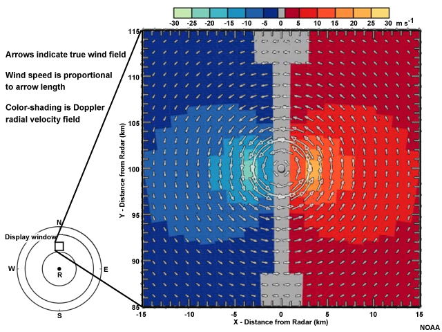
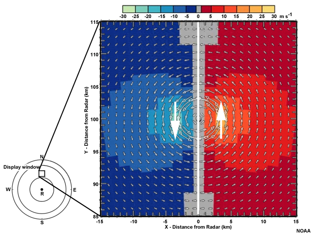
The left side of the graphic shows a 30 by 30 kilometer square located 100 kilometers north of the radar. The right side shows radial velocities over the square. The arrows show a strong counterclockwise circulation about the center of the square. A zero isodop runs north-to-south and bisects the square. On the right side of the zero isodop there are outbound velocities in red, with closed isodops surrounding a maximum that lies about 3 kilometers to the east of the square's center. On the left side of the zero isodop there are inbound velocities in blue, with closed isodops surrounding a minimum that lies about 3 kilometers to the west of the square's center.
File Name:
brown_wood_pure_rot_ccw.jpg
Credits:
NOAA
Copyright Terms:
COMET Standard Terms of Use
Description:
The left side of the graphic shows velocity vectors within a 30 by 30 kilometer square located 100 kilometers north of the radar. The right side shows radial velocities over the square. The arrows show a strong counterclockwise circulation about the center of the square. A zero isodop runs north-to-south and bisects the square. On the right side of the zero isodop there are outbound velocities in red, with closed isodops surrounding a maximum that lies about 3 kilometers to the east of the square's center. On the left side of the zero isodop there are inbound velocities in blue, with closed isodops surrounding a minimum that lies about 3 kilometers to the west of the square's center. Arrows highlight a wind direction of south over the blue minimum and north over the red maximum.
File Name:
brown_wood_pure_rot_ccw_print2.jpg
Credits:
NOAA
Copyright Terms:
COMET Standard Terms of Use
Description:
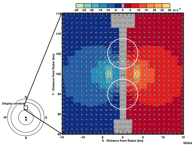
The left side of the graphic shows velocity vectors within a 30 by 30 kilometer square located 100 kilometers north of the radar. The right side shows radial velocities over the square. The arrows show a strong counterclockwise circulation about the center of the square. A zero isodop runs north-to-south and bisects the square. On the right side of the zero isodop there are outbound velocities in red, with closed isodops surrounding a maximum that lies about 3 kilometers to the east of the square's center. On the left side of the zero isodop there are inbound velocities in blue, with closed isodops surrounding a minimum that lies about 3 kilometers to the west of the square's center. The easterly and westerly winds to the north and south, respectively, of the radar location are highlighted.
File Name:
brown_wood_pure_rot_ccw_print3.jpg
Credits:
NOAA
Copyright Terms:
COMET Standard Terms of Use
Description:
Summary image showing storm-scale rotational couplets existing in all four cardinal directions from the radar. All couplets are centered about a zero isodop that is parallel to the radar beam in any given direction. Couplet interfaces and radar radials are highlighted.
File Name:
brown_wood_rot_summary_ann.jpg
Credits:
NOAA
Copyright Terms:
COMET Standard Terms of Use
Description:
Idealized radial velocity patterns for an incoming tropical cyclone in the Northern Hemisphere.
File Name:
brown_wood_TC.mp4
Credits:
NOAA
Copyright Terms:
COMET Standard Terms of Use
Description:
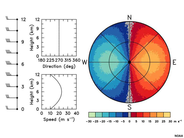
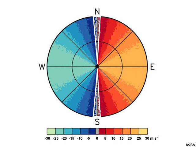
A plan view of idealized radial velocity. Colors to the left of the radar are blue and green, while colors to the right are red and yellow. A line of gray, indicating velocities of zero, bisects the radar area and passes through the radar location. Closed isodops exist within both halves of the radar image.
File Name:
brown_wood_uni_jet.jpg
Credits:
NOAA
Copyright Terms:
COMET Standard Terms of Use
Description:
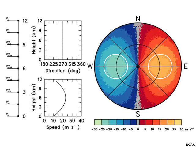
A plan view of idealized radial velocity. Colors to the left of the radar are blue and green, while colors to the right are red and yellow. A line of gray, indicating velocities of zero, bisects the radar area and passes through the radar location. Closed isodops exist within both halves of the radar image and are highlighted in white.
File Name:
brown_wood_uni_jet_print.jpg
Credits:
NOAA
Copyright Terms:
COMET Standard Terms of Use
Description:
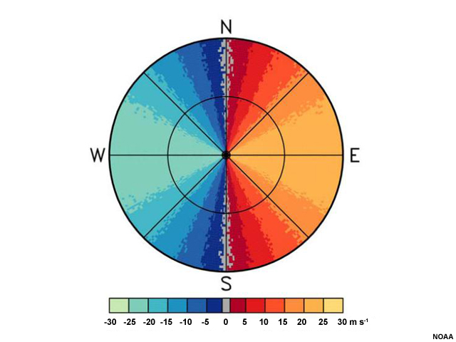
A plan view of idealized radial velocity. Colors to the left of the radar are blue and green, while colors to the right are red and yellow. A line of gray, indicating velocities of zero, bisects the radar area and passes through the radar location.
File Name:
brown_wood_uni_ppi.jpg
Credits:
NOAA
Copyright Terms:
COMET Standard Terms of Use
Description:
A plan view of idealized radial velocity. Colors to the left of the radar are blue and green, while colors to the right are red and yellow. A line of gray, indicating velocities of zero, bisects the radar area and passes through the radar location. Arrows perpendicular to and at the end of the radials denote the wind direction.
File Name:
brown_wood_uni_ppi_range1_direction.jpg
Credits:
NOAA
Copyright Terms:
COMET Standard Terms of Use
Description:
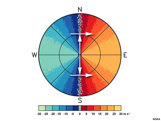
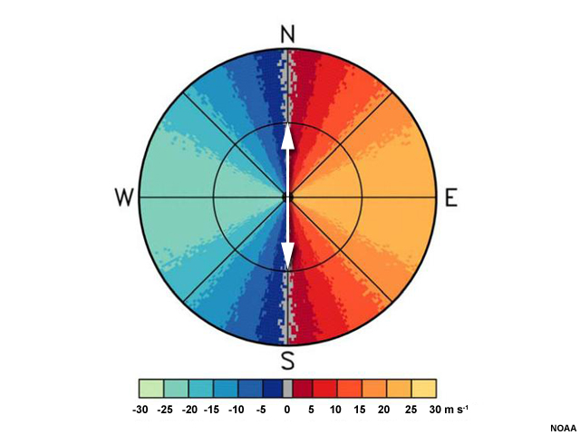
A plan view of idealized radial velocity. Colors to the left of the radar are blue and green, while colors to the right are red and yellow. A line of gray, indicating velocities of zero, bisects the radar area and passes through the radar location. Two radials extend north and south to the first range ring.
File Name:
brown_wood_uni_ppi_range1_radials.jpg
Credits:
NOAA
Copyright Terms:
COMET Standard Terms of Use
Description:
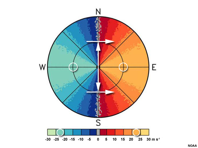
A plan view of idealized radial velocity. Colors to the left of the radar are blue and green, while colors to the right are red and yellow. A line of gray, indicating velocities of zero, bisects the radar area and passes through the radar location. Arrows denote the wind direction and circles mark the wind speed at the first range ring.
File Name:
brown_wood_uni_ppi_rr1.jpg
Credits:
NOAA
Copyright Terms:
COMET Standard Terms of Use
Description:
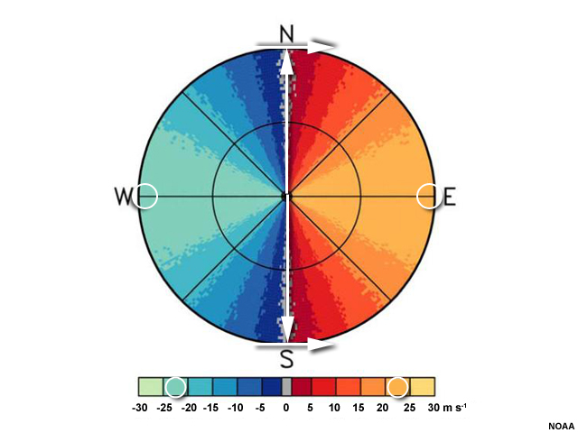
A plan view of idealized radial velocity. Colors to the left of the radar are blue and green, while colors to the right are red and yellow. A line of gray, indicating velocities of zero, bisects the radar area and passes through the radar location. Arrows denote the wind direction and circles mark the wind speed at the last range ring.
File Name:
brown_wood_uni_ppi_rr2.jpg
Credits:
NOAA
Copyright Terms:
COMET Standard Terms of Use
Description:
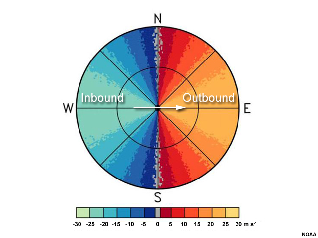
A plan view of idealized radial velocity. Colors to the left of the radar are blue and green, while colors to the right are red and yellow. A line of gray, indicating velocities of zero, bisects the radar area and passes through the radar location. Red and yellow regions are labeled "outbound" while blue and green regions are labeled "inbound". A white arrow points to the east over the radar location.
File Name:
brown_wood_uni_ppi_sfc.jpg
Credits:
NOAA
Copyright Terms:
COMET Standard Terms of Use
Description:
A plan view of idealized radial velocity. Colors to the left of the radar are blue and green, while colors to the right are red and yellow. A line of gray, indicating velocities of zero, bisects the radar area and passes through the radar location. This area is called the zero isodop, and is outlined in white.
File Name:
brown_wood_uni_ppi_zeroisodop.jpg
Credits:
NOAA
Copyright Terms:
COMET Standard Terms of Use
Description:
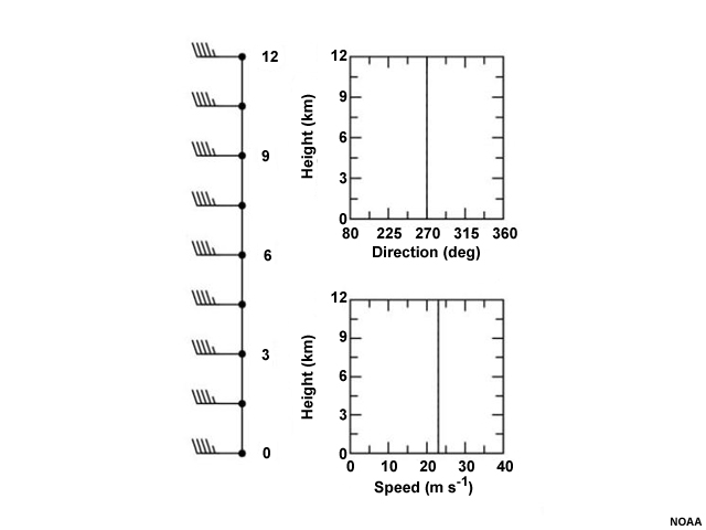
Vertical wind profile showing all winds from the west at 45 kts.
File Name:
brown_wood_uni_profile.jpg
Credits:
NOAA
Copyright Terms:
COMET Standard Terms of Use
Description:
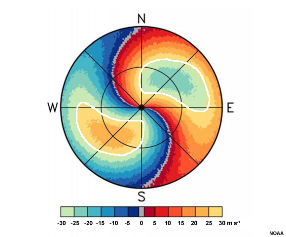
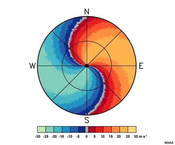
A plan view of idealized radial velocity. Colors to the left of the radar are blue and green, while colors to the right are red and yellow. A line of gray, indicating velocities of zero, forms an "S" shape and intersects the location of the radar in its center. Red and yellow colors lie to the right of the "S" and blue and green colors lie to the left of the "S".
File Name:
brown_wood_veering_ppi.jpg
Credits:
NOAA
Copyright Terms:
COMET Standard Terms of Use
Description:
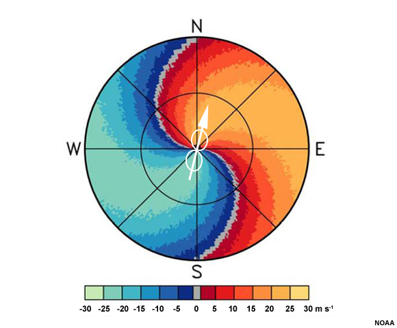
A plan view of idealized radial velocity. Colors to the left of the radar are blue and green, while colors to the right are red and yellow. A line of gray, indicating velocities of zero, forms an "S" shape and intersects the location of the radar in its center. Red and yellow colors lie to the right of the "S" and blue and green colors lie to the left of the "S". An arrow goes from southwest to northeast through the center of the diagram, with circles annotating the maximum wind speeds of 20-25 ms-1 there and on the legend.
File Name:
brown_wood_veering_ppi_sfc.jpg
Credits:
NOAA
Copyright Terms:
COMET Standard Terms of Use
Description:
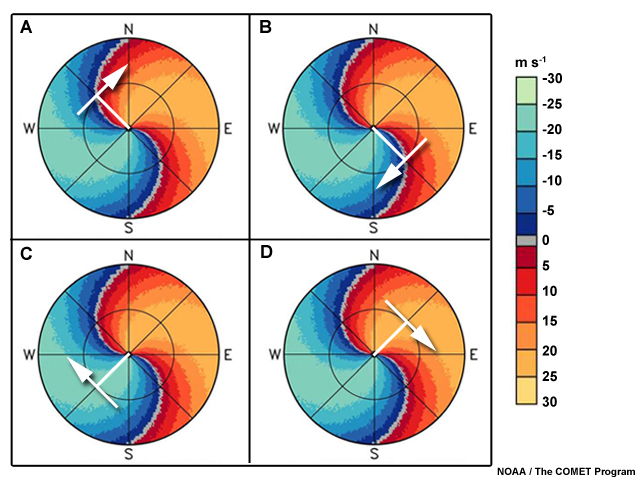
A plan view of idealized radial velocity. Colors to the left of the radar are blue and green, while colors to the right are red and yellow. A line of gray, indicating velocities of zero, forms an "S" shape and intersects the location of the radar in its center. Red and yellow colors lie to the right of the "S" and blue and green colors lie to the left of the "S". Option A shows a radial extending to the northwest, and an arrow at the end of it pointing directly to the northeast. Option B shows a radial extending to the southeast, and an arrow at the end of it pointing directly to the southwest. Option C shows a radial extending to the northeast, and an arrow at the end of it pointing directly to the southeast. Option D shows a radial extending to the southwest, and an arrow at the end of it pointing directly to the northwest.
File Name:
brown_wood_veering_q1.jpg
Credits:
NOAA / The COMET Program
Copyright Terms:
COMET Standard Terms of Use
Description:
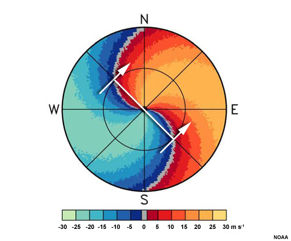
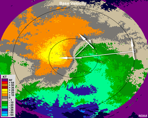
A plan view of idealized radial velocity. Colors to the left of the radar are blue and green, while colors to the right are red and yellow. A line of gray, indicating velocities of zero, forms an "S" shape and intersects the location of the radar in its center. Red and yellow colors lie to the right of the "S" and blue and green colors lie to the left of the "S". Radials drawn to the location of the zero isodop extend to the northwest and southeast. Arrows drawn perpendicularly to these radials from the inbound velocities toward the outbound ones indicate that winds are out of the southwest.
File Name:
brown_wood_veering_q1_feedback.jpg
Credits:
NOAA / The COMET Program
Copyright Terms:
COMET Standard Terms of Use
Description:
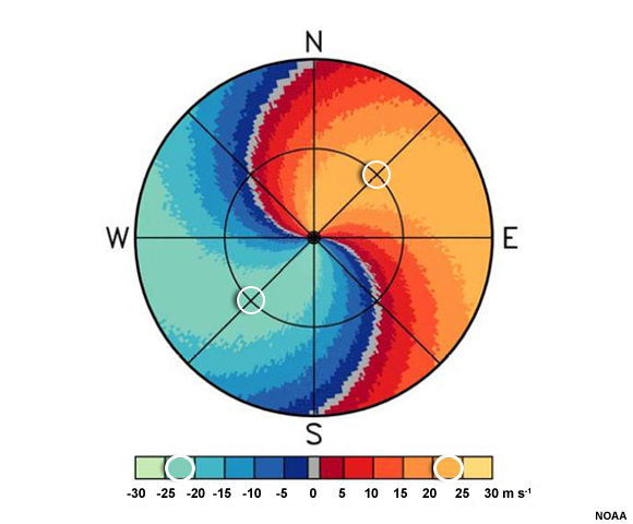
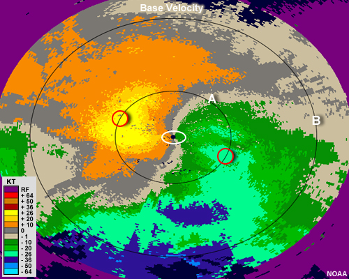
A plan view of idealized radial velocity. Colors to the left of the radar are blue and green, while colors to the right are red and yellow. A line of gray, indicating velocities of zero, forms an "S" shape and intersects the location of the radar in its center. Red and yellow colors lie to the right of the "S" and blue and green colors lie to the left of the "S". Two circles at the level of the first range ring are drawn within the maximum of outbound colors and the minimum of inbound colors. These circles correspond to the orange and aqua colors, respectively, that are between 20 and 25 knots.
File Name:
brown_wood_veering_q2_feedback.jpg
Credits:
NOAA
Copyright Terms:
COMET Standard Terms of Use
Description:
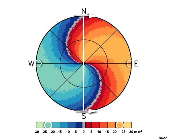
A plan view of idealized radial velocity. Colors to the left of the radar are blue and green, while colors to the right are red and yellow. A line of gray, indicating velocities of zero, forms an "S" shape and intersects the location of the radar in its center. Red and yellow colors lie to the right of the "S" and blue and green colors lie to the left of the "S". Radials drawn from the radar location to the zero isodop where it intersects the edge of the radar range extend to the north and south. Arrows drawn perpendicularly to the radials and from inbound winds toward outbound ones indicate that the winds are westerly. The maximum and minimum winds at this range are orange and aqua, corresponding to 20 to 25 meters per second.
File Name:
brown_wood_veering_q3_feedback.jpg
Credits:
NOAA / The COMET Program
Copyright Terms:
COMET Standard Terms of Use
Description:
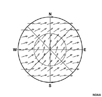
Wind vectors for a veering wind field on radial velocity diagram.
File Name:
brown_wood_veering_totalwind.jpg
Credits:
NOAA
Copyright Terms:
COMET Standard Terms of Use
Description:
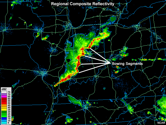
Several mini bow echoes form a line running roughly north to south on composite radar reflectivity
File Name:
cent_missvly_201006142330.jpg
Credits:
NCAR
Copyright Terms:
COMET Standard Terms of Use
Description:
NEXRAD clear air mode volume scan pattern (VCP 31, 32)
File Name:
clear_mode_scan_diagram.jpg
Credits:
NOAA
Copyright Terms:
COMET Standard Terms of Use
Description:
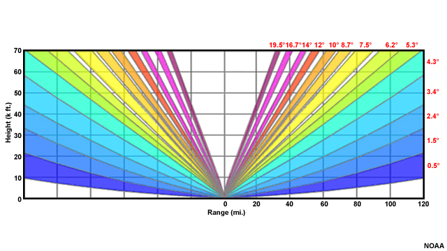
Depiction of a radar scanning pattern at different elevations. A triangular area above the radar is empty to indicate the area that is not scanned--called the cone of silence
File Name:
cone_silence_beams.jpg
Credits:
NOAA
Copyright Terms:
COMET Standard Terms of Use
Description:
Depiction of a radar scanning pattern at different elevations. A triangular area above the radar is empty to indicate the area that is not scanned--called the cone of silence.
File Name:
cone_silence_beams_q.jpg
Credits:
NOAA
Copyright Terms:
COMET Standard Terms of Use
Description:
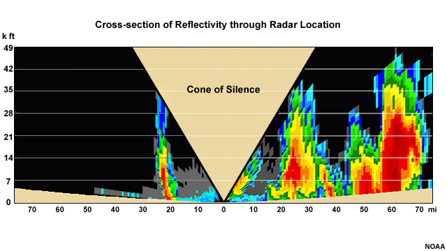
Radar reflectivity cross-section through the location of a radar.
File Name:
cone_silence_xsection.jpg
Credits:
NOAA
Copyright Terms:
COMET Standard Terms of Use
Description:
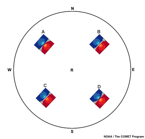
An idealized radial velocity image showing four couplets that depict clockwise rotation,
counterclockwise rotation, divergence, and convergence
File Name:
couplet_questions.jpg
Credits:
NOAA / The COMET Program
Copyright Terms:
COMET Standard Terms of Use
Description:
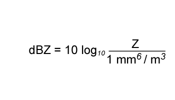
dBZ equation
File Name:
dbz_eq.jpg
Credits:
© The COMET Program
Copyright Terms:
COMET Standard Terms of Use
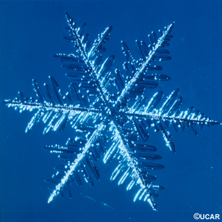
Description:
Magnified image of a snowflake
File Name:
DI00310.jpg
Credits:
© UCAR
Copyright Terms:
COMET Standard Terms of Use
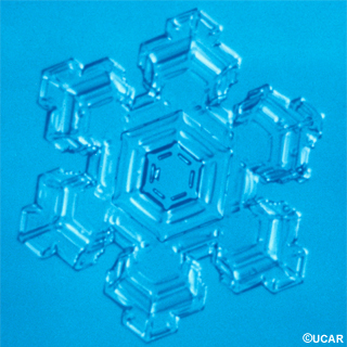
Description:
Magnified image of a snowflake
File Name:
DI00314.jpg
Credits:
© UCAR
Copyright Terms:
COMET Standard Terms of Use
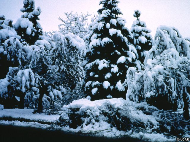
Description:
Wet, heavy snow accumulating on tree branches and bending them toward the ground.
File Name:
DI00373.jpg
Credits:
© UCAR
Copyright Terms:
COMET Standard Terms of Use
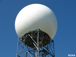
Description:
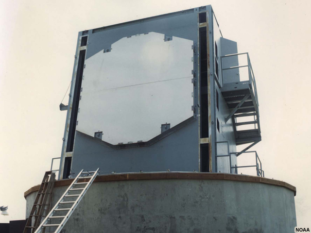
A NEXRAD radar dome
File Name:
dome_rc.jpg
Credits:
NOAA
Copyright Terms:
COMET Standard Terms of Use
Description:
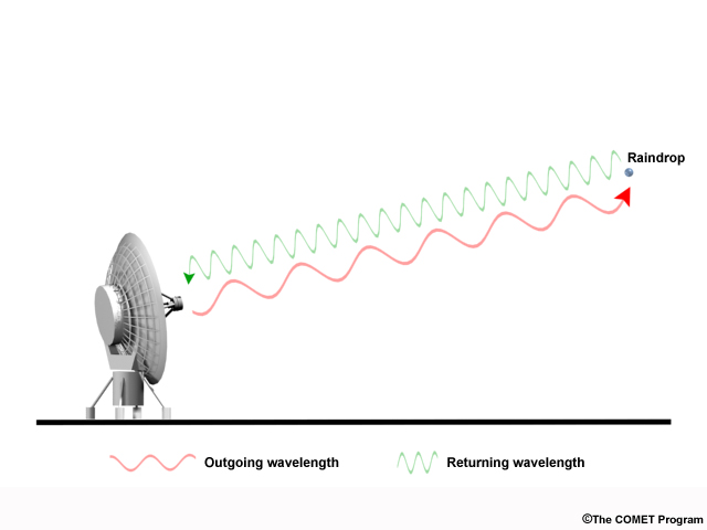
Radar emitting pulses at a specific wavelength. When the pulses are reflected back toward the radar, the wavelength is shorter.
File Name:
doppler_shift_waves.jpg
Credits:
© The COMET Program
Copyright Terms:
COMET Standard Terms of Use
Description:
Video of a car honking its horn while approaching and then traveling away from an observer
File Name:
doppler_sound.mp4
Credits:
© The COMET Program
Copyright Terms:
COMET Standard Terms of Use
Description:
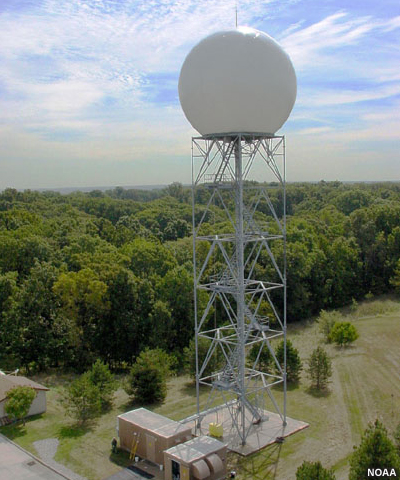
Photograph of an NWS Doppler radar tower as viewed from approximately the same level aerially.
File Name:
doppler_tower_aerial.jpg
Credits:
NOAA
Copyright Terms:
COMET Standard Terms of Use
Description:
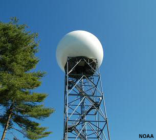
Photograph of an NWS Doppler radar tower as viewed from the ground.
File Name:
doppler_tower_from_below.jpg
Credits:
NOAA
Copyright Terms:
COMET Standard Terms of Use
Description:
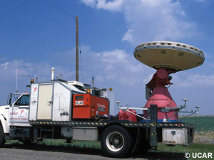
A Doppler on Wheels portable radar
File Name:
dow.jpg
Credits:
© UCAR
Copyright Terms:
COMET Standard Terms of Use
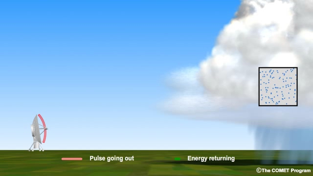
Description:
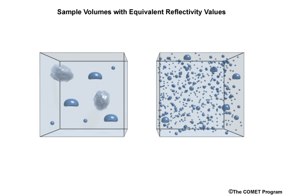
Sample Volumes with Equivalent Reflectivity Values
File Name:
dsd_samples_simple.jpg
Credits:
© The COMET Program
Copyright Terms:
COMET Standard Terms of Use
Description:
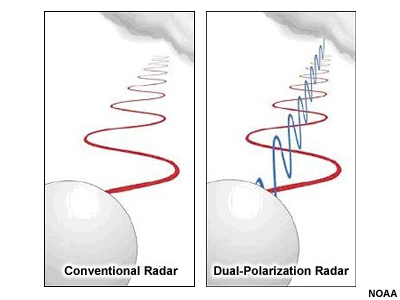
Comparison of pulse patterns between a conventional radar and a dual-polarization radar
File Name:
dual_pol2.jpg
Credits:
NOAA
Copyright Terms:
COMET Standard Terms of Use
Description:
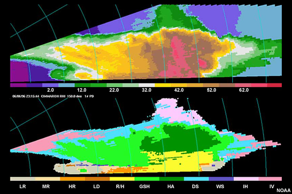
Example of a radar image from a dual-polarization radar
File Name:
dual_polarization.jpg
Credits:
NOAA
Copyright Terms:
COMET Standard Terms of Use
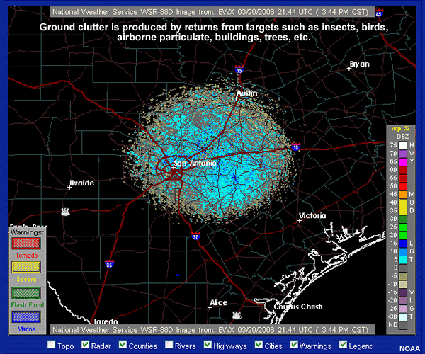
Description:
Radar image with ground clutter
File Name:
gc2.jpg
Credits:
NOAA
Copyright Terms:
COMET Standard Terms of Use
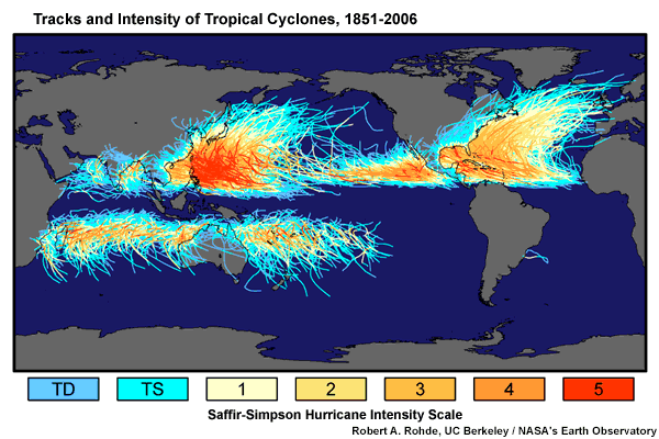
Description:
Tracks and intensities of tropical cyclones from 1851-2006
File Name:
GlobalTropicalCycloneMap.gif
Credits:
NASA
Copyright Terms:
COMET Standard Terms of Use
Description:
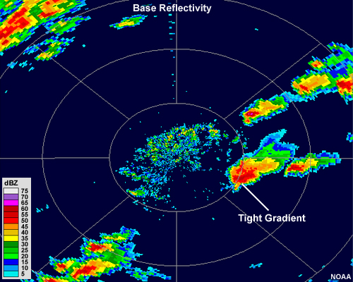
Two radar reflectivity images. The thunderstorms in the left panel are not as strong as the ones in the right panel, where there is a very sharp change from almost no radar return to over 60 dBZ in the cores in some of the larger cells.
File Name:
hail_bref_comparison.jpg
Credits:
NOAA
Copyright Terms:
COMET Standard Terms of Use
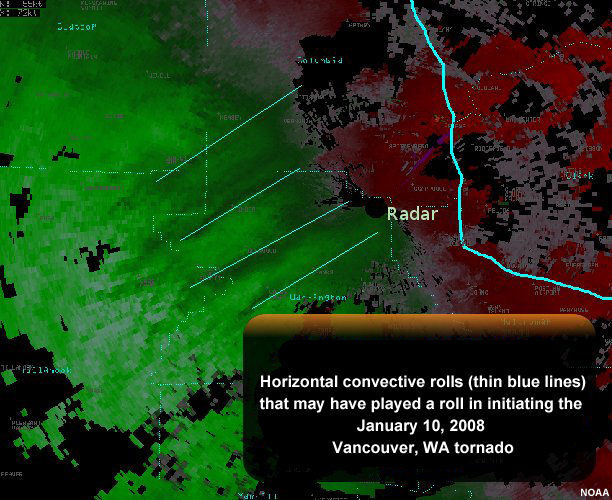
Description:
Radar image showing reflectivity from horizontal convective rolls that may have played a roll in initiating the January 10, 2008 Vancouver, WA tornado
File Name:
hcr.jpg
Credits:
NOAA
Copyright Terms:
COMET Standard Terms of Use
Description:
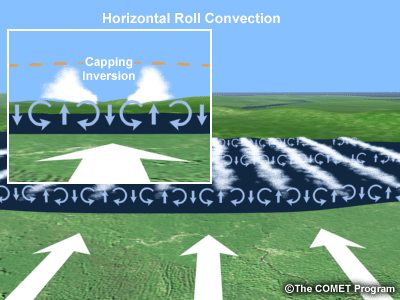
Horizontal roll convection over body of water
File Name:
horiz_roll_convection.gif
Credits:
© The COMET Program
Copyright Terms:
COMET Standard Terms of Use
Description:
Horizontal roll convection over body of water
File Name:
horiz_roll_convection.gif
Credits:
© The COMET Program
Copyright Terms:
COMET Standard Terms of Use
Description:
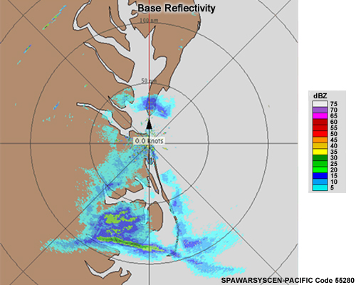
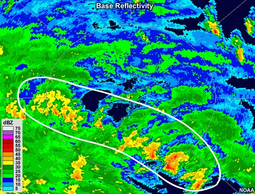
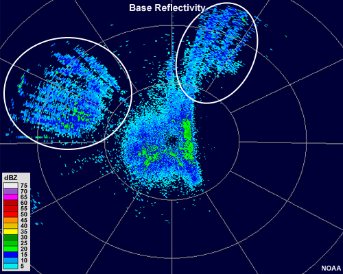
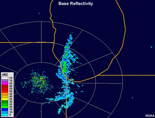
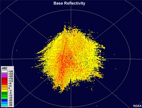
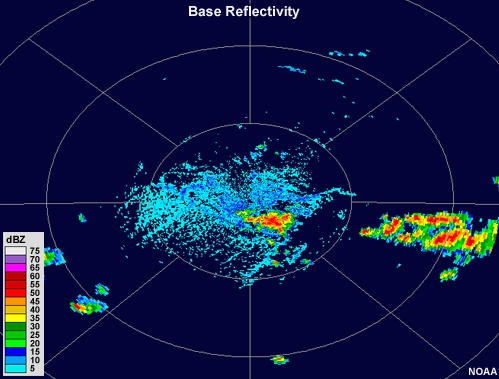
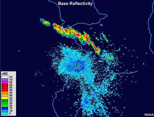
Military radar system base reflectivity image showing light and moderate precipitation to the south of the radar.
File Name:
HWDDC_20070430_bref.jpg
Credits:
SPAWARSYSCEN-PACIFIC Code 55280
Copyright Terms:
COMET Standard Terms of Use
Description:
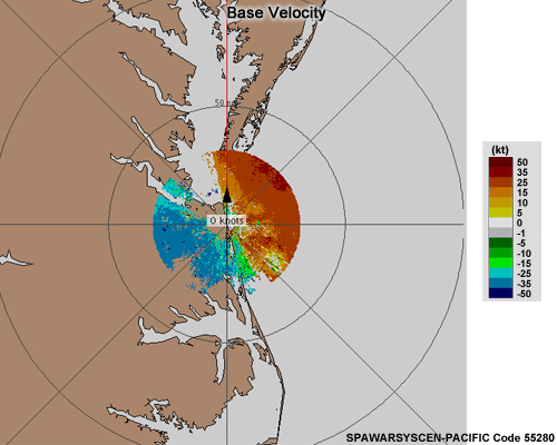
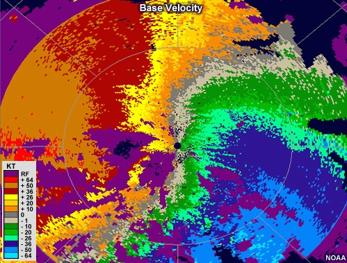
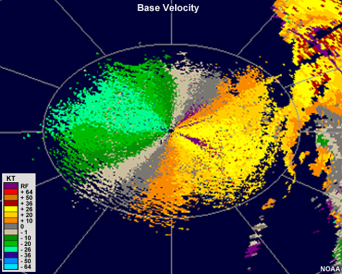
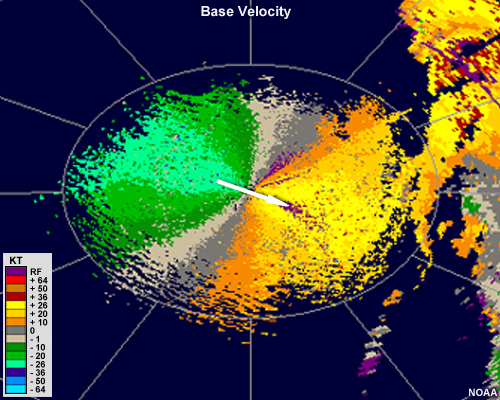
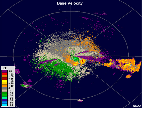
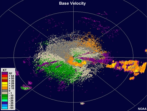
Military radar system base velocity image showing shades of blue and green to the west of the radar and shades of orange and red to the east of the radar.
File Name:
HWDDC_20111029_vel.jpg
Credits:
SPAWARSYSCEN-PACIFIC Code 55280
Copyright Terms:
COMET Standard Terms of Use
Description:
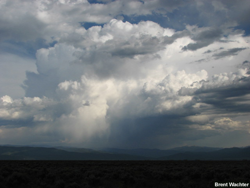
Photo of thunderstorm with very dark rain shaft
File Name:
IMG_0845.jpg
Credits:
Brent Wachter
Copyright Terms:
COMET Standard Terms of Use
Description:
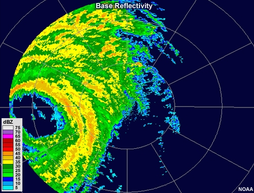
Radar reflectivity loop showing hurricane Wilma making landfall in 2005. The eye, which is free of echo, is large and pronounced. Bands of moderate to high reflectivity values encircle the eye, and other intense bands of precipitation can be seen spiraling outward from the storm's center.
File Name:
KAMX_20051024_bref_loop.mp4
Credits:
NOAA
Copyright Terms:
COMET Standard Terms of Use
Description:
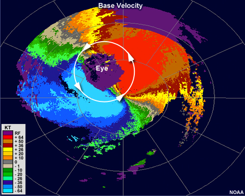
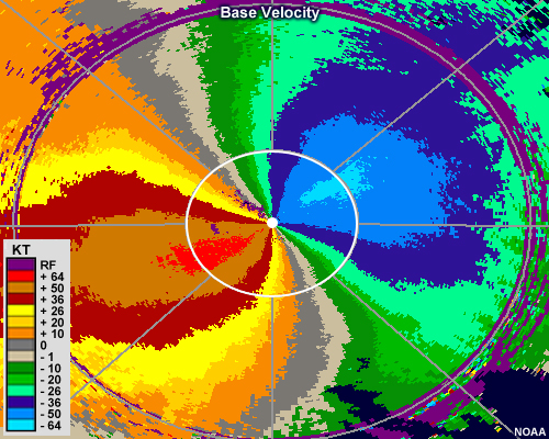
Radial velocity loop showing hurricane Wilma making landfall in 2005. The eye, which is free of echo, is large and pronounced.
File Name:
KAMX_20051024_vel.jpg
Credits:
NOAA
Copyright Terms:
COMET Standard Terms of Use
Description:
Radar reflectivity loop showing moderate intensity cells aligned in bands (or streets) downwind of lake Michigan.
File Name:
KAPX_20120102_bref_loop.mp4
Credits:
NOAA
Copyright Terms:
COMET Standard Terms of Use
Description:
Radial velocity animation showing banded targets headed southeast downwind of lake Michigan.
File Name:
KAPX_20120102_vel_loop.mp4
Credits:
NOAA
Copyright Terms:
COMET Standard Terms of Use
Description:
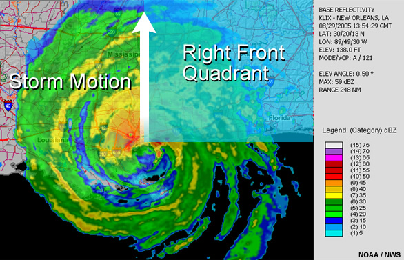
Tornadoes are more likely to form in the right front quadrant of a hurricane
File Name:
katrina.jpg
Credits:
NOAA/NWS
Copyright Terms:
COMET Standard Terms of Use
Description:
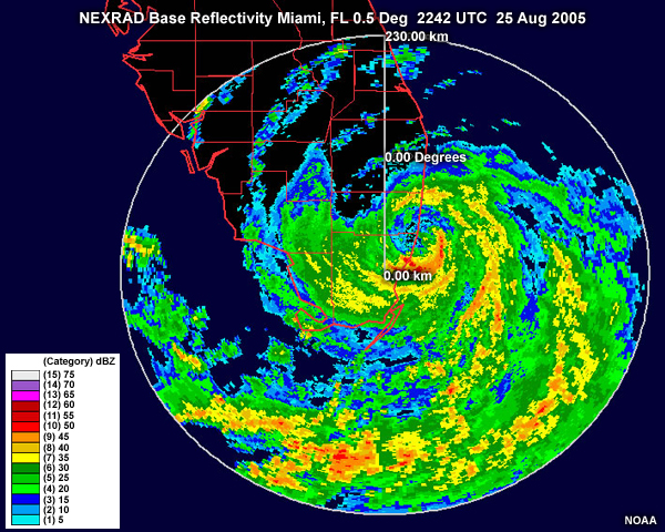
NEXRAD radar image for hurricane Katrina near South Florida.
File Name:
katrina_radar_fla.jpg
Credits:
NOAA
Copyright Terms:
COMET Standard Terms of Use
Description:
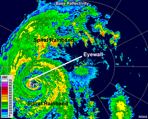
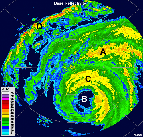
Radar reflectivity image showing hurricane Charley making landfall in 2004. The clear area in the center of the storm is labeled as the eye. The ring of intense precipitation just surrounding the eye is labeled as the eyewall. The bands of moderate to intense precipitation that spiral outward are labeled as spiral rainbands.
File Name:
KBYX_20040813_bref_1040Z_solution.jpg
Credits:
NOAA
Copyright Terms:
COMET Standard Terms of Use
Description:
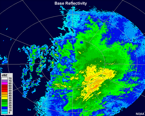
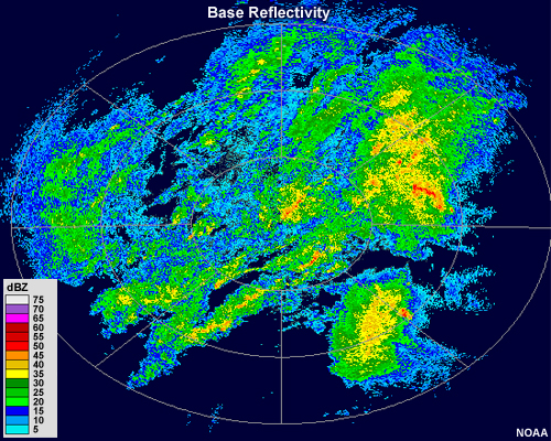
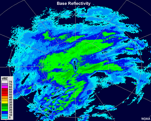
Radar reflectivity showing a large area of moderate and low intensity precipitation. The reflectivity gradient is relatively weak across the radar range and the edges of the echo are somewhat fuzzy.
File Name:
KCCX_20070214_bref_0900Z.jpg
Credits:
NOAA
Copyright Terms:
COMET Standard Terms of Use
Description:
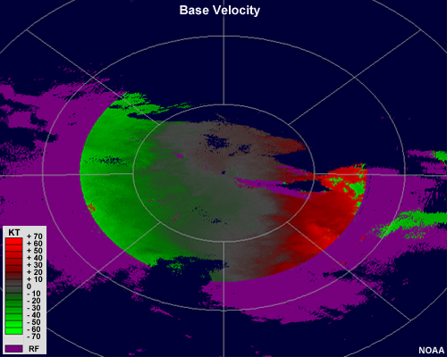
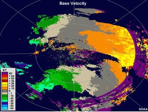
Base velocity image showing shades of green west of the radar and shades of red east of the radar. A ring of purple, indicating range folding, exists at the edges of the radar range.
File Name:
KCCX_20111220_vel_1713Z.jpg
Credits:
NOAA
Copyright Terms:
COMET Standard Terms of Use
Description:
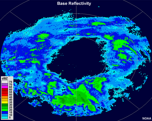
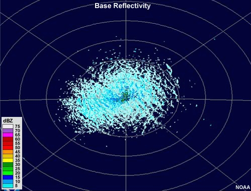
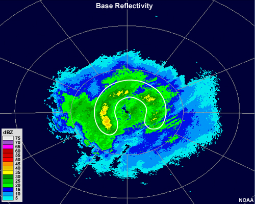
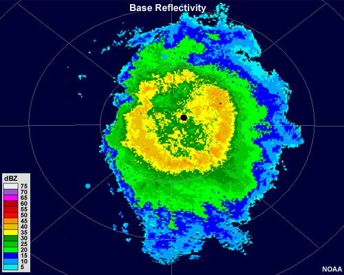
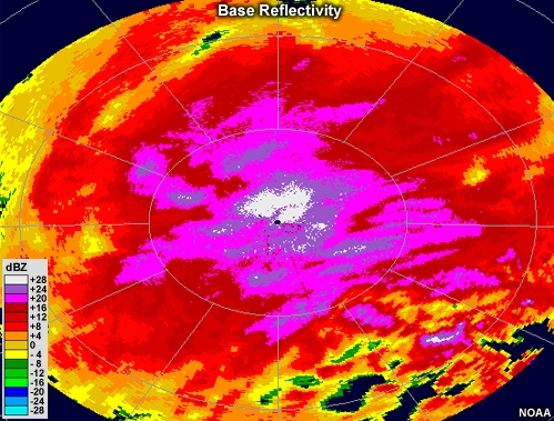
Base Reflectivity image showing a wide ring, or donut, of light to moderate precipitation centered around a radar site.
File Name:
KCCX_20120125_bref_0259Z.jpg
Credits:
NOAA
Copyright Terms:
COMET Standard Terms of Use
Description:
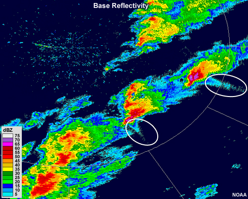
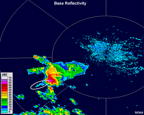
Two large thunderstorm cells with reflectivities of 75+ dBZ in their cores also have protrusions of narrow bands of low reflectivity extending downrange from the radar.
File Name:
KDVN_20101022_bref_2000Z.jpg
Credits:
NOAA
Copyright Terms:
COMET Standard Terms of Use
Description:
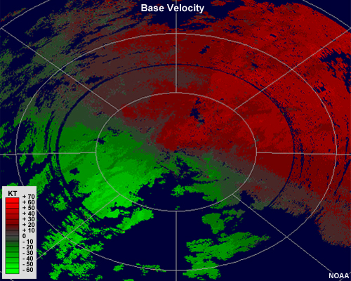
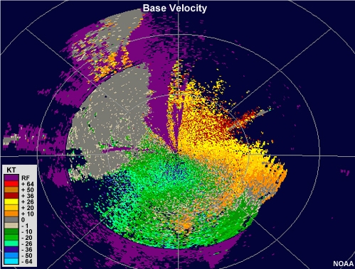
Radial velocity image showing shades of green to the south and west of the radar and shades of red to the north and east of the radar
File Name:
KENX_20090729_vel_2110Z.jpg
Credits:
NOAA
Copyright Terms:
COMET Standard Terms of Use
Description:
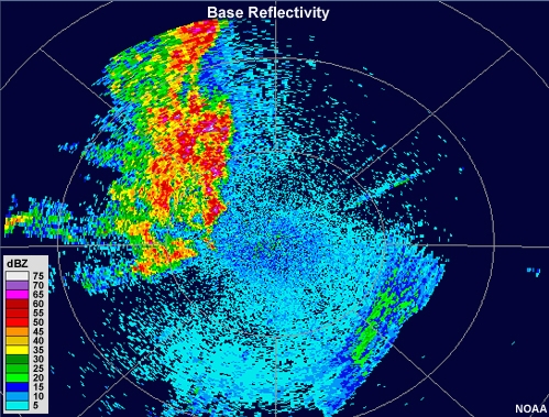
Radar reflectivity showing areas of light, moderate and heavy precipitation. Light precipitation is shown in blue colors, moderate precipitation ranges from dark green into yellow, and heavy precipitation is shown in red and pink shades.
File Name:
KENX_20090730_bref_0200Z.jpg
Credits:
NOAA
Copyright Terms:
COMET Standard Terms of Use
Description:
Radar reflectivity animation showing bands of intense precipitation spiraling couterclockwise about a ring of more intense precipitation with an echo-free region in its center. Several strong, discrete cells are embedded within the northernmost rainbands.
File Name:
KEVX_20040915_bref_loop.mp4
Credits:
NOAA
Copyright Terms:
COMET Standard Terms of Use
Description:
base velocity animation showing several small couplets within a background of very strong southeasterly winds.
File Name:
KEVX_20040915_vel_loop.mp4
Credits:
NOAA
Copyright Terms:
COMET Standard Terms of Use
Description:
Radar reflectivity image showing small intense thunderstorms developing quickly and dissipating
File Name:
KFFC_20100612_bref_loop.mp4
Credits:
NOAA
Copyright Terms:
COMET Standard Terms of Use
Description:
Base reflectivity image showing shades of light blue roughly organized into bands close to the radar.
File Name:
KFSD_19970607_bref_loop.mp4
Credits:
NOAA
Copyright Terms:
COMET Standard Terms of Use
Description:
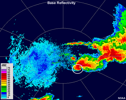
Base reflectivity showing a pronounced, wide hook echo on a supercell thunderstorm
File Name:
KICT_20100916_bref_0048Z.jpg
Credits:
NOAA
Copyright Terms:
COMET Standard Terms of Use
Description:
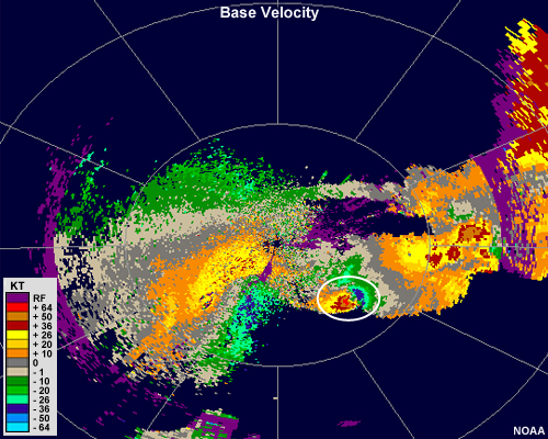
Base reflectivity showing a pronounced, large mesocyclonic circulation
File Name:
KICT_20100916_vel_0048Z.jpg
Credits:
NOAA
Copyright Terms:
COMET Standard Terms of Use
Description:
Radar reflectivity showing a pronounced bow echo within an MCS
File Name:
KILN_20030705_bref_0018Z.jpg
Credits:
NOAA
Copyright Terms:
COMET Standard Terms of Use
Description:
Reflectivity animation showing a large system consisting of a leading line of very intense precipitation followed by a broad area of moderate intensity precipitation. A portion of the leading line of thunderstorms develops a bulge or bow outward toward the front over time.
File Name:
KILN_20030705_bref_loop.mp4
Credits:
NOAA
Copyright Terms:
COMET Standard Terms of Use
Description:
Radial velocity image showing very strong inbound velocities in green to the northwest of the radar. Some are aliased to shades of red.
File Name:
KILN_20030705_vel_0018Z.jpg
Credits:
NOAA
Copyright Terms:
COMET Standard Terms of Use
Description:
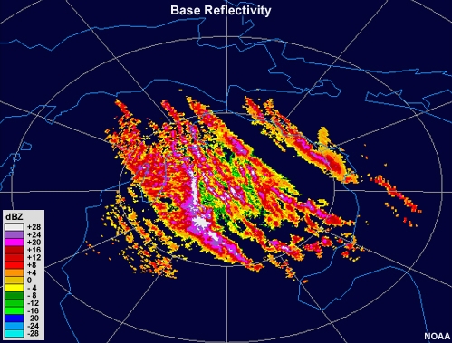
Radar reflectivity loop showing areas of precipitation with a small portion of targets moving against the wind
File Name:
KILX_19990302_bref_loop.mp4
Credits:
NOAA
Copyright Terms:
COMET Standard Terms of Use
Description:
Radar reflectivity animation showing areas of precipitation with a small section of targets that are likely biological
File Name:
KILX_19990302_bref_loop_feedback.mp4
Credits:
NOAA
Copyright Terms:
COMET Standard Terms of Use
Description:
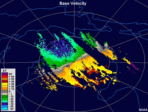
Radial velocity loop showing winds moving toward the radar on the left side of the image and away from the radar on the right. A small area to the southwest of the radar shows an initially divergent couplet that expands in size with time.
File Name:
KILX_19990302_vel_loop.mp4
Credits:
NOAA
Copyright Terms:
COMET Standard Terms of Use
Description:
Radar reflectivity showing widespread, light precipitation over most of the radar range. Closeby the radar a ring of enhanced reflectivities of about 45 dbZ exists.
File Name:
KILX_20050106_bref_0301Z.jpg
Credits:
NOAA
Copyright Terms:
COMET Standard Terms of Use
Description:
Radar reflectivity animation showing an area of light precipitation with subtle banding features that come and go.
File Name:
KIND_20100209_bref_0900Z.jpg
Credits:
NOAA
Copyright Terms:
COMET Standard Terms of Use
Description:
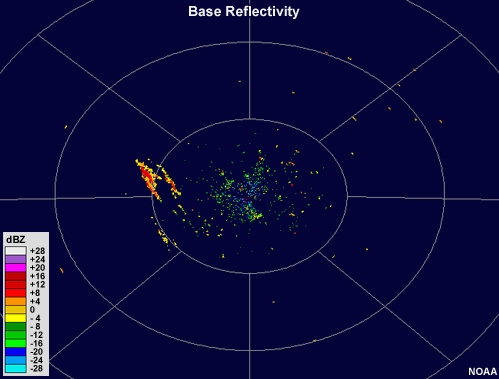
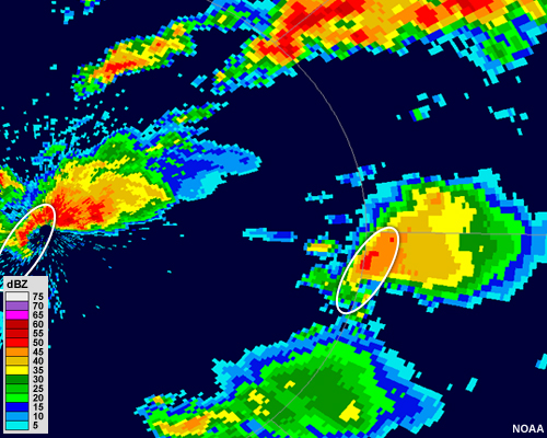
A base reflectivity image showing anomalous propagation
File Name:
KJAX_20090410_bref_0954Z.jpg
Credits:
NOAA
Copyright Terms:
COMET Standard Terms of Use
Description:
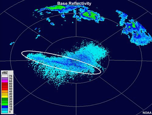
Radar reflectivity animation showing an echo appear at nearly the location of the radar and then elongate toward the northeast over time.
File Name:
KLBB_20060312_bref_loop.mp4
Credits:
NOAA
Copyright Terms:
COMET Standard Terms of Use
Description:
Radar reflectivity showing a fine line of low reflectivity that broadens over time
File Name:
KLBB_20111017_bref_loop.mp4
Credits:
NOAA
Copyright Terms:
COMET Standard Terms of Use
Description:
Base reflectivity image showing bands of intense precipitation.
File Name:
KLIX_20111222_bref_1737Z.jpg
Credits:
NOAA
Copyright Terms:
COMET Standard Terms of Use
Description:
Radar reflectivity animation showing an area of light precipitation with subtle banding features that come and go. The loop begins in clear air mode and then switches to precipitation mode.
File Name:
KLNX_20040208_bref_loop.mp4
Credits:
NOAA
Copyright Terms:
COMET Standard Terms of Use
Description:
Radar reflectivity loop showing moderate intensity cells aligned in a large band that runs north to south along roughly the center of lake Michigan.
File Name:
KLOT_19960307_bref_loop.mp4
Credits:
NOAA
Copyright Terms:
COMET Standard Terms of Use
Description:
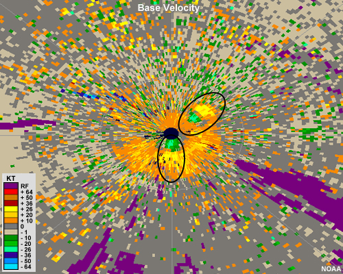
Radial velocity image showing pronounced divergent couplets just to the south and just to the northeast of the radar. Couplets are circled in black.
File Name:
KLSX_20100812_vel_1808Z_print.jpg
Credits:
NOAA
Copyright Terms:
COMET Standard Terms of Use
Description:
Radar reflectivity animation showing long, narrow echoes of low intensity oriented north-to-south. These echoes move toward the east over time.
File Name:
KLVX_20060107_bref_loop.mp4
Credits:
NOAA
Copyright Terms:
COMET Standard Terms of Use
Description:
Base reflectivity image showing scattered areas of intense reflectivity, without a cellular or line nature
File Name:
KMAF_20060424_bref_loop.mp4
Credits:
NOAA
Copyright Terms:
COMET Standard Terms of Use
Description:
Base velocity loop
File Name:
KMAF_20060424_vel_loop.mp4
Credits:
NOAA
Copyright Terms:
COMET Standard Terms of Use
Description:
Radar reflectivity animation showing an enhanced strip of low reflectivity moving north amongst very low reflectivity clutter
File Name:
KMPX_20090519_bref_loop.mp4
Credits:
NOAA
Copyright Terms:
COMET Standard Terms of Use
Description:
A base velocity image
File Name:
KMVX_vel_interp_1.jpg
Credits:
NOAA
Copyright Terms:
COMET Standard Terms of Use
Description:
Radial velocity image showing blue and green colors to the north and west of the radar and red and yellow colors to the south and east of the radar.
File Name:
KMVX_vel_interp_1_q2_feedback.jpg
Credits:
NOAA
Copyright Terms:
COMET Standard Terms of Use
Description:
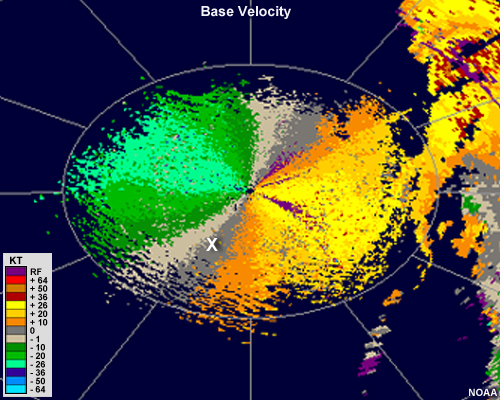
Radial velocity image showing blue and green colors to the north and west of the radar and red and yellow colors to the south and east of the radar. A white X is positioned to the south-southwest of the radar along the zero isodop.
File Name:
KMVX_vel_interp_1_q3.jpg
Credits:
NOAA
Copyright Terms:
COMET Standard Terms of Use
Description:
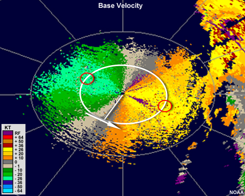
Radial velocity image showing blue and green colors to the north and west of the radar and red and yellow colors to the south and east of the radar. A white X is positioned to the south-southwest of the radar along the zero isodop. A radial drawn from the radar to the X is capped by a perpendicular arrow that points to the southeast. The maximum and minimum winds at that range are colored in aqua and yellow, corresponding to approximately 26 knots.
File Name:
KMVX_vel_interp_1_q3_feedback.jpg
Credits:
NOAA
Copyright Terms:
COMET Standard Terms of Use
Description:
Base reflectivity image showing a large, round supercell with a small appendage of high reflectivities that protrudes southward. This is sometimes called a "pendant" echo
File Name:
KOAX_20040523_bref_0128Z.jpg
Credits:
NOAA
Copyright Terms:
COMET Standard Terms of Use
Description:
Base velocity showing a coupling of strong inbound velocities and strong outbound velocities indicating a counterclockwise rotating mesocyclone
File Name:
KOAX_20040523_vel_0128Z.jpg
Credits:
NOAA
Copyright Terms:
COMET Standard Terms of Use
Description:
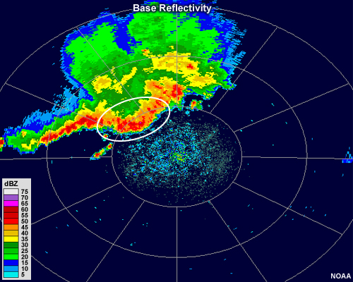
Radar reflectivity image showing a large, intense circular thunderstorm with a small hook echo on its southern flank
File Name:
KOHX_20021110_bref_2201Z.jpg
Credits:
NOAA
Copyright Terms:
COMET Standard Terms of Use
Description:
A base reflectivity image with an almost complete circle of enhanced reflectivity around the radar site indicating the presence of melting snowflakes
File Name:
KOKX_20010130_bref.jpg
Credits:
NOAA
Copyright Terms:
COMET Standard Terms of Use
Description:
Radar reflectivity animation showing a large, steady band of moderate intensity precipitation and several smaller bands of light intensity that come and go.
File Name:
KOKX_20060212_bref_loop.mp4
Credits:
NOAA
Copyright Terms:
COMET Standard Terms of Use
Description:
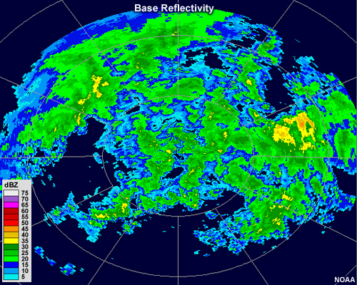
Radar reflectivity animation showing widespread, scattered cells of weak to moderate precipitation
File Name:
KPAH_20120125_bref_1815Z.jpg
Credits:
NOAA
Copyright Terms:
COMET Standard Terms of Use
Description:
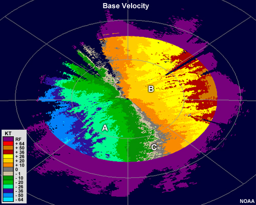
Radial velocity image showing shades of green to the west of the radar and shades of red to the east of the radar.
File Name:
KRTX_20111228_vel_1713Z.jpg
Credits:
NOAA
Copyright Terms:
COMET Standard Terms of Use
Description:
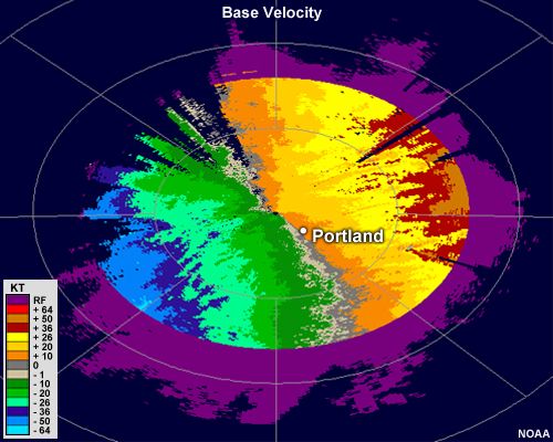
Radial velocity image showing shades of green to the west of the radar and shades of red to the east of the radar.
File Name:
KRTX_20111228_vel_1713Z_question.jpg
Credits:
NOAA
Copyright Terms:
COMET Standard Terms of Use
Description:
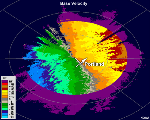
Radial velocity image showing shades of green to the west of the radar and shades of red to the east of the radar. A white radial is drawn from the radar southeast to the location of Portland. An arrow is drawn perpendicularly to the radial, and pointing from the inbound winds to the southwest toward the outbound winds that exist to the northeast of portland.
File Name:
KRTX_20111228_vel_1713Z_solution.jpg
Credits:
NOAA
Copyright Terms:
COMET Standard Terms of Use
Description:
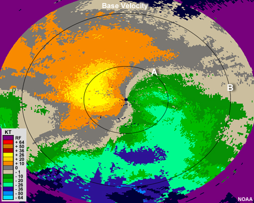
Radial velocity image
File Name:
KSRX_20120125_vel_0558Z.jpg
Credits:
NOAA
Copyright Terms:
COMET Standard Terms of Use
Description:
Radial velocity image with arrows denoting how to interpret wind direction.
File Name:
KSRX_20120125_vel_0558Z_q1_feedback.jpg
Credits:
NOAA
Copyright Terms:
COMET Standard Terms of Use
Description:
Radial velocity image with arrows denoting how to interpret wind speed
File Name:
KSRX_20120125_vel_0558Z_q2_feedback.jpg
Credits:
NOAA
Copyright Terms:
COMET Standard Terms of Use
Description:
radar reflectivity showing several long, narrow lines of low value that advect over time.
File Name:
KTLX_20110311_bref_loop.mp4
Credits:
NOAA
Copyright Terms:
COMET Standard Terms of Use
Description:
radar reflectivity showing several long, narrow lines of low value that advect over time.
File Name:
KTLX_20110311_bref_loop_ans.jpg
Credits:
NOAA
Copyright Terms:
COMET Standard Terms of Use
Description:
Radar reflectivity animation showing a distinct low-reflectivity fine line oriented from southwest to northeast. Several intense thunderstorms develop a short distance ahead of the line.
File Name:
KTLX_20110414_bref_loop.mp4
Credits:
NOAA
Copyright Terms:
COMET Standard Terms of Use
Description:
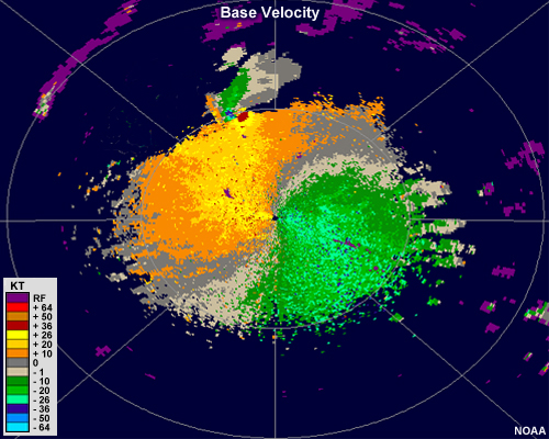
Base velocity image showing shades of green east of the radar and shades of orange west of the radar. Further northwest from the radar, there is a small region of strong outbound velocities in red adjacent to a small region of strong inbound velocities in blue.
File Name:
KTLX_N0V_20100519_2230Z.jpg
Credits:
NOAA
Copyright Terms:
COMET Standard Terms of Use
Description:
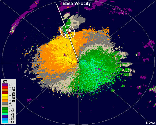
Base velocity image showing shades of green east of the radar and shades of orange west of the radar. Northwest from the radar, there is a small region of strong outbound velocities in red adjacent to a small region of strong inbound velocities in blue. This rotational couple is circled and a white line is drawn along the radial to the couplet. An arrow pointing to the south-southeast is drawn through the left half of the couplet, and an arrow pointing the opposite direction is drawn through the right half of the couplet.
File Name:
KTLX_N0V_20100519_2230Z_ann.jpg
Credits:
NOAA
Copyright Terms:
COMET Standard Terms of Use
Description:
Radar reflectivity still image showing areas of precipitation with a small portion of targets (possibly birds) moving against the wind
File Name:
KTYX_20100801_bref_loop.jpg
Credits:
NOAA
Copyright Terms:
COMET Standard Terms of Use
Description:
Radar reflectivity loop showing areas of precipitation with a small portion of targets moving against the wind
File Name:
KTYX_20100801_bref_loop.mp4
Credits:
NOAA
Copyright Terms:
COMET Standard Terms of Use
Description:
A large thunderstorm with a core containing 75+ dBZ values with a protruding, narrow line of weak reflectivity extending downrange of the radar.
File Name:
KUEX_20080726_bref_1918Z.jpg
Credits:
NOAA
Copyright Terms:
COMET Standard Terms of Use
Description:
Radar reflectivity showing an circular fine line that emanates from a cluster of small but intense thunderstorm cells.
File Name:
KUEX_20090604_bref_loop.mp4
Credits:
NOAA
Copyright Terms:
COMET Standard Terms of Use
Description:
Radar velocity showing a large area of strong outbound velocities aligned with a cluster of thunderstorms, with an adjacent small region of strong inbound velocities that is slightly closer to the radar
File Name:
KUEX_20090604_vel_2113Z.jpg
Credits:
NOAA
Copyright Terms:
COMET Standard Terms of Use
Description:
Radar velocity showing a large area of strong outbound velocities aligned with a cluster of thunderstorms, with an adjacent small region of strong inbound velocities that is slightly closer to the radar
File Name:
KUEX_20090604_vel_loop.mp4
Credits:
NOAA
Copyright Terms:
COMET Standard Terms of Use
Description:
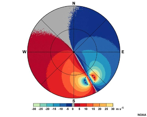
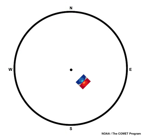
An idealized divergent couplet is shown to the southeast of a radar location.
File Name:
KUEX_ideal_couplet_comp.jpg
Credits:
NOAA / The COMET Program
Copyright Terms:
COMET Standard Terms of Use
Description:
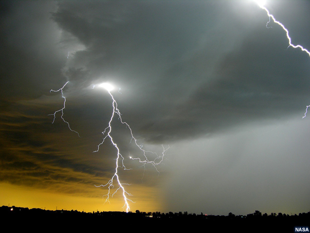
A thunderstorm cloud viewed from the ground with spectacular lightning strikes next to a thick rain shaft. The sun angle makes the background color a brilliant golden yellow. Nitrogen oxide molecules are indicated near the lightning strike.
File Name:
lightning_rainshaft_yellow_background.jpg
Credits:
NASA
Copyright Terms:
COMET Standard Terms of Use
Description:
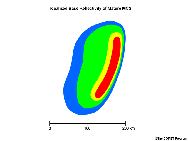
Idealized appearance of an MCS thunderstorm on radar reflectivity.
File Name:
MCS_bref_concept.jpg
Credits:
© The COMET Program
Copyright Terms:
COMET Standard Terms of Use
Description:
Radar animation of an MCS that caused widespread damage as it moved over Oklahoma and Texas, United States. The animation shows 10 hours of the system's lifetime.
File Name:
MCS_derecho_01.mp4
Credits:
NOAA
Copyright Terms:
COMET Standard Terms of Use
Description:
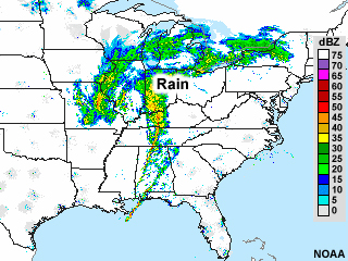
National Reflectivity Image showing a mass of moderate to light precipitation over Missouri and Illinois. A wide swath of moderate to light intensity precipitation extends east-northeastward to New York, while a narrower band of more intense precipitation extends southward through Alabama
File Name:
nowrad_national_20090211.jpg
Credits:
NOAA
Copyright Terms:
COMET Standard Terms of Use
Description:
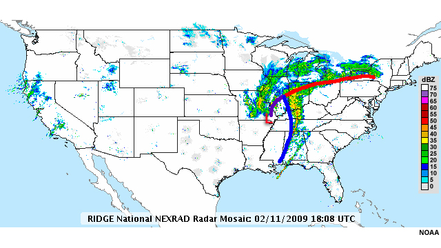
National Reflectivity Image showing a mass of moderate to light precipitation over Missouri and Illinois. A wide swath of moderate to light intensity precipitation extends east-northeastward to New York and coincides with a warm front denoted in red, while a narrower band of more intense precipitation extends southward through Alabama and coincides with a cold front marked in blue.
File Name:
nowrad_national_20090211_nolabel_print.jpg
Credits:
NOAA
Copyright Terms:
COMET Standard Terms of Use
Description:
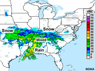
National Reflectivity Image showing a mass of moderate to light precipitation over Oklahoma. A wide swath of moderate to light intensity precipitation extends eastward to through Arkansas, Tennessee and into the Carolinas. A broad band of more intense precipitation extends southward through Alabama and Mississippi.
File Name:
nowrad_national_20100129.jpg
Credits:
NOAA
Copyright Terms:
COMET Standard Terms of Use
Description:
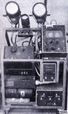
Control and indicators of an old radar unit installed at a weather station.
File Name:
old_wx_radar.jpg
Credits:
NOAA
Copyright Terms:
COMET Standard Terms of Use
Description:
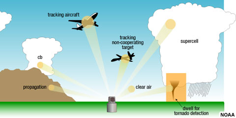
Conceptual diagram of multiple uses of a phased array radar
File Name:
par_cartoon.jpg
Credits:
NOAA
Copyright Terms:
COMET Standard Terms of Use
Description:
Phased array radar antennae
File Name:
par_radar.jpg
Credits:
NOAA
Copyright Terms:
COMET Standard Terms of Use
Description:
NEXRAD precipitation volume scan pattern (VCP 11)
File Name:
precip_mode_scan_diagram.jpg
Credits:
NOAA
Copyright Terms:
COMET Standard Terms of Use
Description:
Conceptual animation of the precipitation processes inside a tropical cumulonimbus cloud
File Name:
precip_process_cb_ocean.mp4
Credits:
© The COMET Program
Copyright Terms:
COMET Standard Terms of Use
Description:
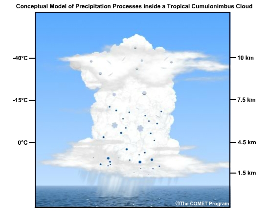
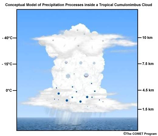
Conceptual model of the precipitation processes inside a tropical cumulonimbus cloud
File Name:
precip_process_cb_ocean_static.jpg
Credits:
© The COMET Program
Copyright Terms:
COMET Standard Terms of Use
Description:
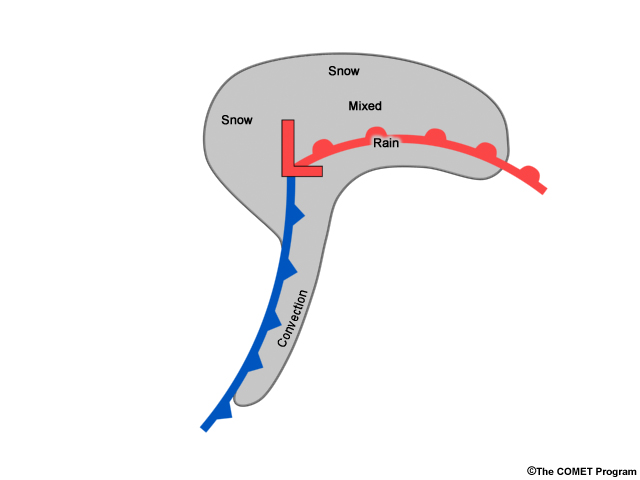
Conceptual diagram of a low pressure system with cold and warm fronts. Snow occurs to the northwest of low and north of warm front, mixed precip occurs just north of the warm front, and rain occurs along and south of the warm front. Convection occurs along and ahead of the cold front.
File Name:
precip_type_concept_map.jpg
Credits:
© The COMET Program
Copyright Terms:
COMET Standard Terms of Use
Description:
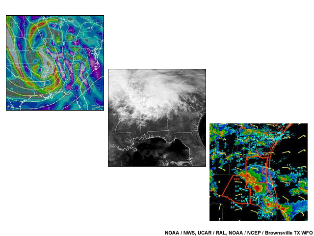
Collage of 3 different weather forecasting products
File Name:
products_collage.jpg
Credits:
NOAA / NWS, UCAR / RAL, NOAA / NCEP / Brownsville TX WFO
Copyright Terms:
COMET Standard Terms of Use
Description:
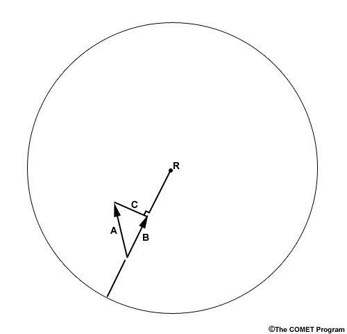
A radial extends from the location of the radar to the edge of the radar's viewing range. Along this radial is a vector that points toward the radar. It is labeled A. Another longer vector points approximately 30 degrees to the left of this vector. It is labeled B. A third vector connects the ends of vectors A and B, and is at a right angle to the radial. It is labeled C.
File Name:
quiz_doppler_components.jpg
Credits:
© The COMET Program
Copyright Terms:
COMET Standard Terms of Use
Description:
Reflectivity loop for quiz.
File Name:
quiz_reflectivity_loop.mp4
Credits:
NOAA
Copyright Terms:
COMET Standard Terms of Use
Description:
Reflectivity image for quiz.
File Name:
quiz_tropical_cyclone.jpg
Credits:
NOAA
Copyright Terms:
COMET Standard Terms of Use
Description:
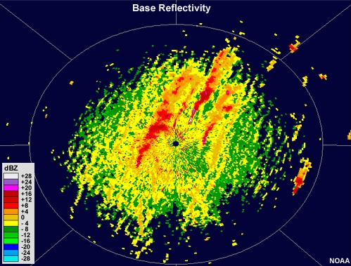
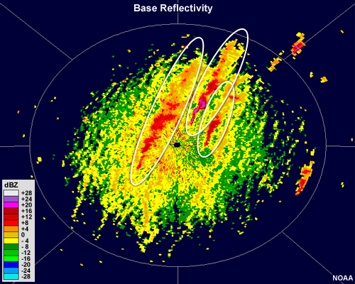
A radial velocity image. A line of gray runs approximately northwest to southeast through the radar location. Warm shades exist to the left of the line and cool shades are to the right. Dark orange and medium blue shades touch the radar location. Bright red and light blue shades represent the maximum and minimum values possible, and are collocated with the first range ring.
File Name:
quiz_vel_interp_1.jpg
Credits:
NOAA
Copyright Terms:
COMET Standard Terms of Use
Description:
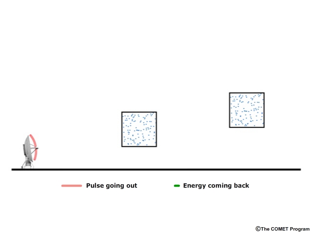
Conceptual diagram of radar attenuation
File Name:
radar_atten.mp4
Credits:
© The COMET Program
Copyright Terms:
COMET Standard Terms of Use
Description:
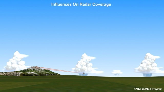
Influences on radar coverage area
File Name:
radar_coverage.mp4
Credits:
© The COMET Program
Copyright Terms:
COMET Standard Terms of Use
Description:
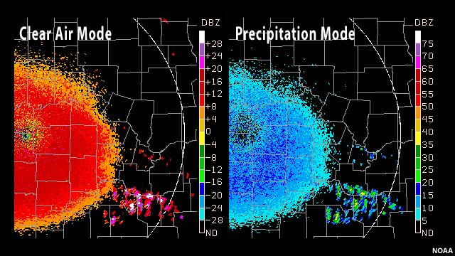
Comparison of base reflectivity image in clear air mode and precipitation mode
File Name:
radar_operational_modes_bref.jpg
Credits:
NOAA
Copyright Terms:
COMET Standard Terms of Use
Description:
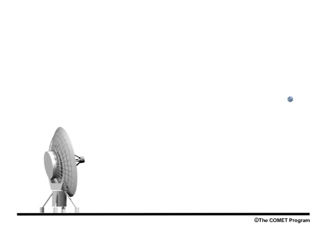
Conceptual diagram of a radar pulse being scattered by a target
File Name:
radar_ops.mp4
Credits:
© The COMET Program
Copyright Terms:
COMET Standard Terms of Use
Description:
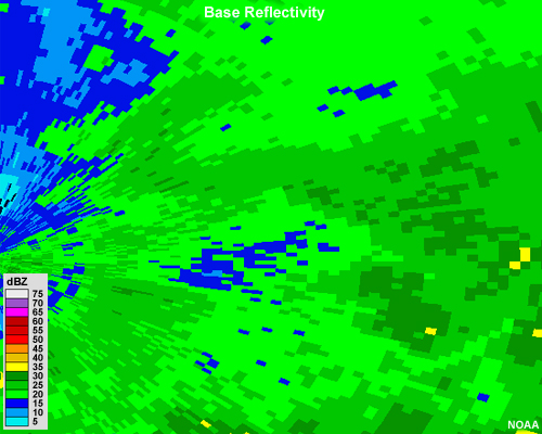
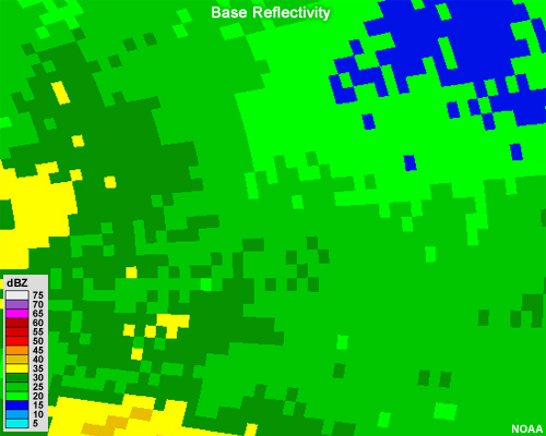
Base reflectivity image showing moderate precipitation across the radar image. The pixels of the image are somewhat small.
File Name:
radar_proximity_question_1.jpg
Credits:
NOAA
Copyright Terms:
COMET Standard Terms of Use
Description:
Base reflectivity image showing moderate precipitation across the radar image. The pixels of the image are somewhat large.
File Name:
radar_proximity_question_2.jpg
Credits:
NOAA
Copyright Terms:
COMET Standard Terms of Use
Description:
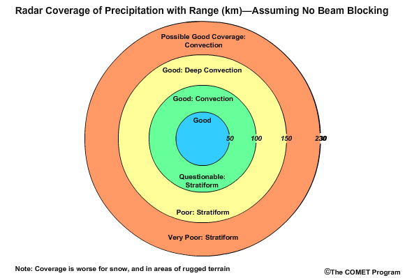
Expected radar coverage of precipitation with range.
File Name:
radar_range_coverage_still.jpg
Credits:
© The COMET Program
Copyright Terms:
COMET Standard Terms of Use
Description:
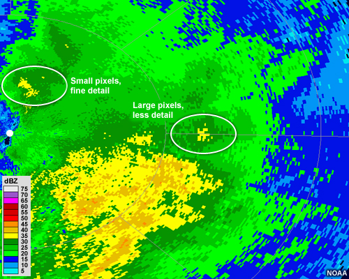
Zoomed view of a radar reflectivity image illustrating the pixel size close to the radar and far away from the radar
File Name:
radar_resolution_distance_example.jpg
Credits:
NOAA
Copyright Terms:
COMET Standard Terms of Use
Description:
Animation of electromagnetic pulses being sent by radar and returned by targets in the atmosphere. The radar antenna rotates an incremental amount before sending each pulse.
File Name:
radar_scan_EM_animation.mp4
Credits:
© The COMET Program
Copyright Terms:
COMET Standard Terms of Use
Description:
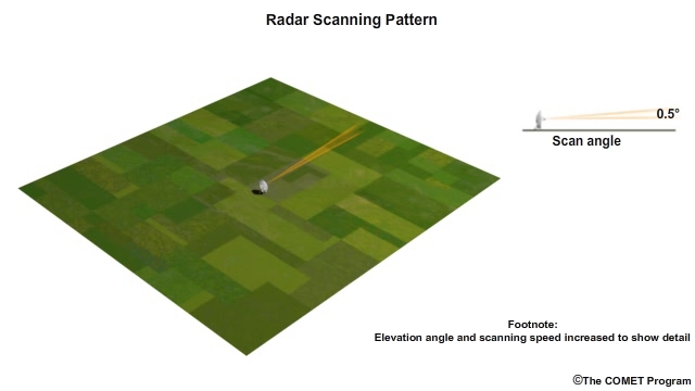
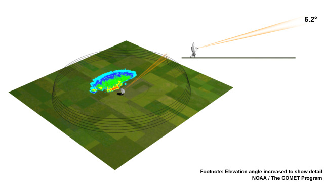
A still image from the radar scanning animation depicting the scanning pattern and a small amount of ground clutter
File Name:
radar_scan_EM_animation_still1.jpg
Credits:
NOAA / The COMET Program
Copyright Terms:
COMET Standard Terms of Use
Description:
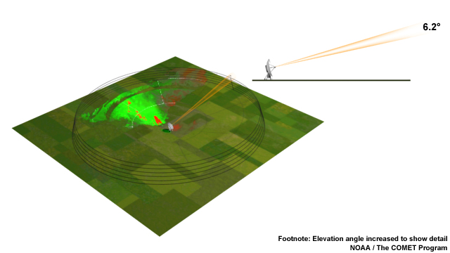
A still from the radar scan animation that depicts a radar scanning pattern with an area showing radial velocity data
File Name:
radar_scan_EM_animation_still2.jpg
Credits:
NOAA / The COMET Program
Copyright Terms:
COMET Standard Terms of Use
Description:
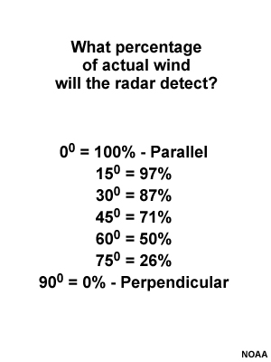
Table describing the percentage of actual wind the radar will detect depending on the angle of the wind with respect to the radar.
File Name:
radar_wind.jpg
Credits:
NOAA
Copyright Terms:
COMET Standard Terms of Use
Description:
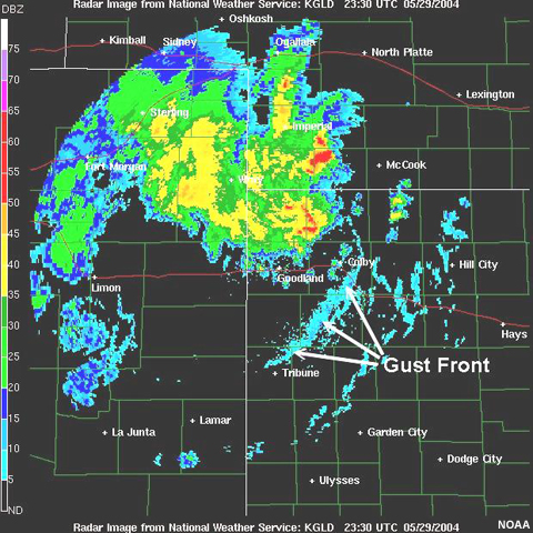
Radar image showing a cluster of thunderstorms and associated gust front
File Name:
raddust.jpg
Credits:
NOAA
Copyright Terms:
COMET Standard Terms of Use
Description:
Conceptual model of radar pulse and back-scatter from raindrops
File Name:
radop1.mp4
Credits:
© The COMET Program
Copyright Terms:
COMET Standard Terms of Use
Description:
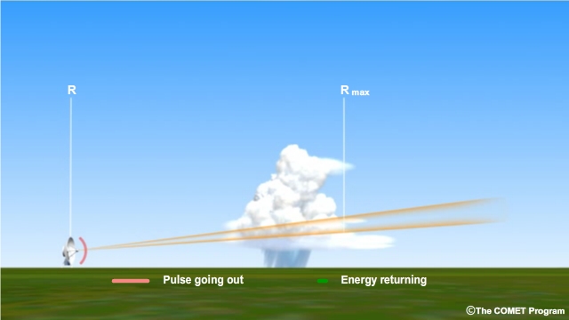
Example of when a radar target lies within the radar's maximum unambiguous range.
File Name:
range_folding_animation_1.mp4
Credits:
© The COMET Program
Copyright Terms:
COMET Standard Terms of Use
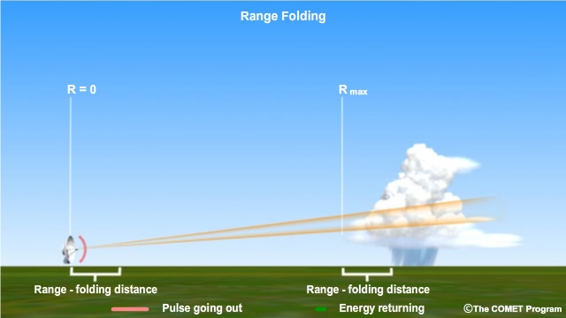
Description:
Example of when a radar target lies outside the radar's maximum unambiguous range.
File Name:
range_folding_animation_2.mp4
Credits:
© The COMET Program
Copyright Terms:
COMET Standard Terms of Use
Description:
Example of a correctly located mass of precipitation within the radar's maximum unambiguous range
File Name:
range_folding_ppi_1.jpg
Credits:
© The COMET Program
Copyright Terms:
COMET Standard Terms of Use
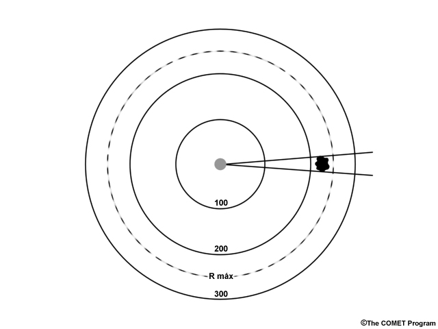
Description:
Example of an incorrectly located mass of precipitation that was outside of the maximum unambiguous range. The precipitation is shown being much closer to the radar and takes on a narrow shape
File Name:
range_folding_ppi_2.jpg
Credits:
© The COMET Program
Copyright Terms:
COMET Standard Terms of Use
Description:
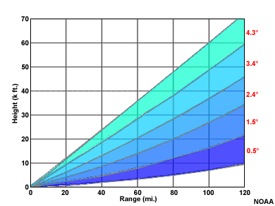
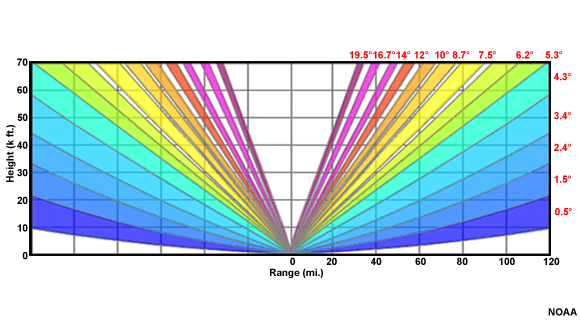
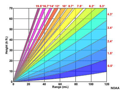
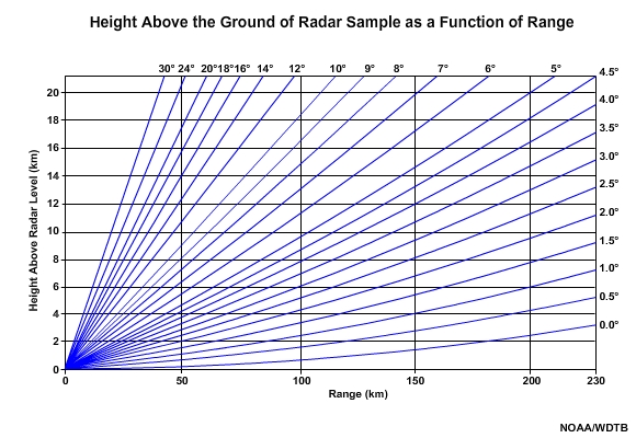
Radar sample height above the ground as a function of distance (range) from the radar
File Name:
rangevsheight.jpg
Credits:
NOAA/WDTB
Copyright Terms:
COMET Standard Terms of Use
Description:
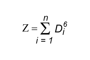
Radar reflectivity equation
File Name:
ref_eq.jpg
Credits:
© The COMET Program
Copyright Terms:
COMET Standard Terms of Use
Description:
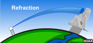
Refraction of a radar beam under standard atmospheric conditions
File Name:
refraction.jpg
Credits:
NOAA
Copyright Terms:
COMET Standard Terms of Use
Description:
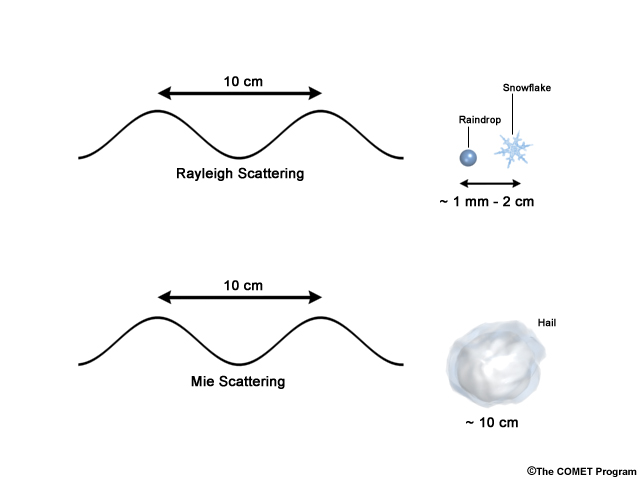
Conceptual model of Rayleigh and Mie Scattering Regimes
File Name:
scatter.jpg
Credits:
© The COMET Program
Copyright Terms:
COMET Standard Terms of Use
Description:
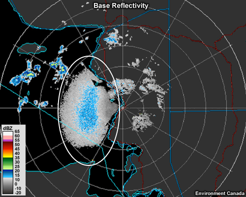
A radar reflectivity image shows a large grainy-looking area of low-intensity echo just to the west of a coastline.
File Name:
sea_clutter_bref.jpg
Credits:
Environment Canada
Copyright Terms:
COMET Standard Terms of Use
Description:
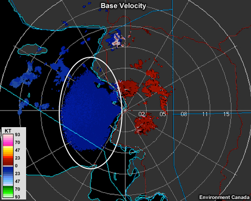
A radial velocity image shows a region of low inbound velocities just to the west of a shoreline
File Name:
sea_clutter_vel.jpg
Credits:
Environment Canada
Copyright Terms:
COMET Standard Terms of Use
Description:
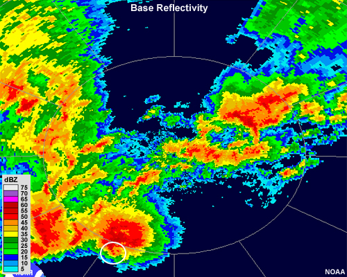
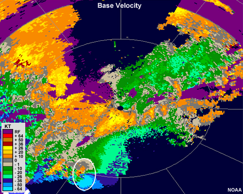
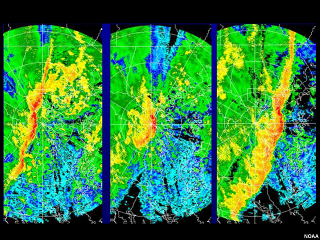
Three panel example of radar attenuation during the passage of a squall line
File Name:
squall_atten.jpg
Credits:
NOAA
Copyright Terms:
COMET Standard Terms of Use
Description:
Base reflectivity image showing difference in detail depending on distance from the radar
File Name:
storm_resolution_comparison.jpg
Credits:
NOAA
Copyright Terms:
COMET Standard Terms of Use
Description:
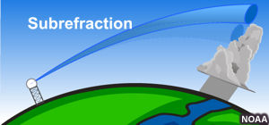
Subrefraction: When a radar beam refracts (bends) less than it would under standard atmospheric conditions
File Name:
sub_refraction.jpg
Credits:
NOAA
Copyright Terms:
COMET Standard Terms of Use
Description:
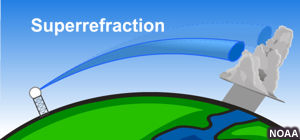
Superrefraction: When a radar beam refracts (bends) morethan it would under standard atmospheric conditions
File Name:
super_refraction.jpg
Credits:
NOAA
Copyright Terms:
COMET Standard Terms of Use
Description:
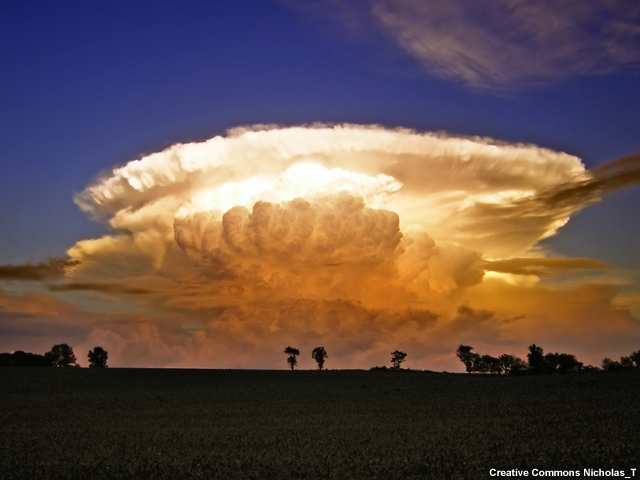
A beautiful reddish to orange to yellow to off-white colored thunderstorm (from bottom to top respectively) grows into a bluish-purple sky over farm land with patchy forest of deciduous trees. The updraft is fleecy/woolly about half as wide as the feather-edged, otherwise crisp Frisbee-shaped anvil.
File Name:
supercell.jpg
Credits:
Creative Commons Nicholas_T
Copyright Terms:
Creative Commons Attribution 2.0 Generic
Description:
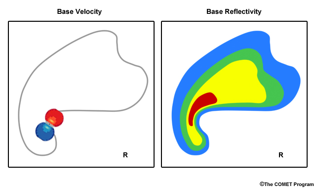
Idealized radar reflectivity of a supercell thunderstorm and its hook echo. Idealized signature of rotation on radial velocity within a supercell thunderstorm.
File Name:
supercell_bref_vel_concept.jpg
Credits:
© The COMET Program
Copyright Terms:
COMET Standard Terms of Use
Description:
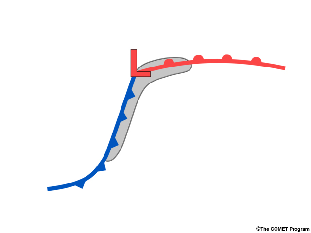
Idealized radar reflectivity showing area that supercells are most commonly found within a low pressure system
File Name:
supercell_concept_map.jpg
Credits:
© The COMET Program
Copyright Terms:
COMET Standard Terms of Use
Description:
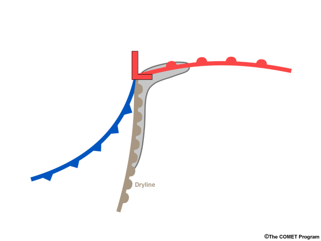
Idealized radar reflectivity showing area that supercells are most commonly found within a low pressure system
File Name:
supercell_concept_map_2.jpg
Credits:
© The COMET Program
Copyright Terms:
COMET Standard Terms of Use
Description:
Tornado damaged home
File Name:
tornado_home.jpg
Credits:
© UCAR
Copyright Terms:
COMET Standard Terms of Use
Description:
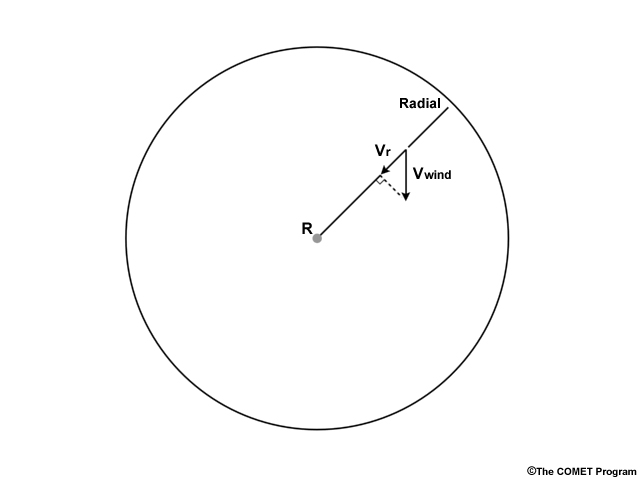
Diagram showing components of motion for a target in a radar's observing range
File Name:
toward_away_components.jpg
Credits:
© The COMET Program
Copyright Terms:
COMET Standard Terms of Use
Description:
Loop of radar reflectivity showing strong convective cells training over the same basins for 5 hours
File Name:
training01.mp4
Credits:
NOAA
Copyright Terms:
COMET Standard Terms of Use
Description:
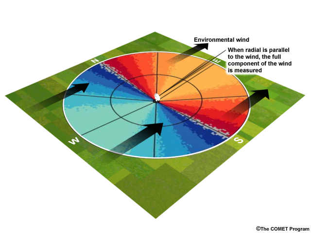
Illustration of the concept of component of the environmental wind velocity measured by a radar. In this image the environmental wind is from the west, and the radar is pointing east
File Name:
vel1.jpg
Credits:
© The COMET Program
Copyright Terms:
COMET Standard Terms of Use
Description:
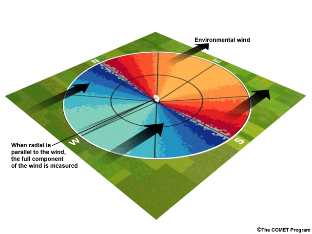
Illustration of the concept of component of the environmental wind velocity measured by a radar. In this image the environmental wind is from the west, and the radar is pointing west
File Name:
vel2.jpg
Credits:
© The COMET Program
Copyright Terms:
COMET Standard Terms of Use
Description:
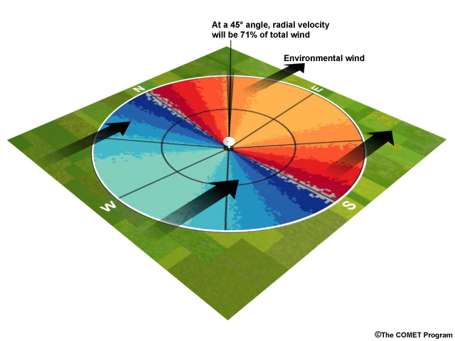
Illustration of the concept of component of the environmental wind velocity measured by a radar. In this image the environmental wind is from the west, and the radar is pointing at 45 degrees (northwest)
File Name:
vel3.jpg
Credits:
© The COMET Program
Copyright Terms:
COMET Standard Terms of Use
Description:
Illustration of the concept of component of the environmental wind velocity measured by a radar. In this image the environmental wind is from the west, and the radar is pointing north
File Name:
vel4.jpg
Credits:
© The COMET Program
Copyright Terms:
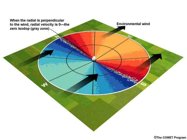
COMET Standard Terms of Use
