Limitations » Processor Assumptions » Angle
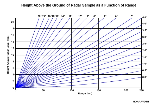
The first assumption is that the radar beam continues to travel through the atmosphere at its original inclination angle setting. As discussed before, most weather radars emit pulses at various elevation angles, ranging between the base scan of 0.5° and 19.5°. Under standard atmospheric conditions (that is, temperature and moisture both decrease with height in the troposphere), the beams will travel along paths that look like this.
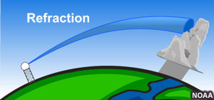
Note that the height of each beam path increases as the beam travels farther away from the radar. This is because of the curvature of the earth. Deviations from these paths may occur depending on the refractive index of the air, which dictates whether electromagnetic waves will refract (that is, bend) when they pass from one material to another. When either a temperature inversion or sharp, vertical moisture gradient is present in the lower troposphere, the refractive index can change with height, essentially bending the radar beam path.
Under normal atmospheric conditions, a radar beam's curvature is slightly less than the earth's curvature.
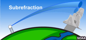
When the radar beam refracts (bends) less than it would under standard atmospheric conditions, it is called "subrefraction." When this occurs, the radar beam is more likely to overshoot areas of interest, and it will exit through the top of any precipitating area more quickly.
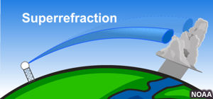
When the beam refracts more than the standard, it is called "superrefraction." In some cases, superrefraction can be so severe that radar pulses intercept the ground or become trapped, which is also known as "ducting." Superrefraction more commonly impacts radar imagery than subrefraction. When superrefraction occurs, the radar beam will bend downward and remain within a precipitating area longer. This can increase the radar's usefulness in examining precipitation that is far away, but may result in exceeding the maximum unambiguous range.
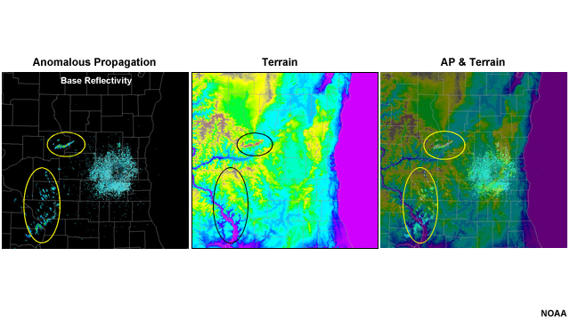
Additionally, the beam may intercept ground targets, creating confusing clutter on radar images. This is commonly called "anomalous propagation." In this example, the radar beams superrefracted enough that they intercepted some local topography that was about 50 km (30 mi) from the radar.
Superrefraction occurs mainly under the following conditions:
- Nocturnal radiation causing a temperature inversion near the ground and a sharp decrease in moisture with height
- A flow of warm, moist air over cooler surfaces, especially water
- A downdraft cooling the area underneath a thunderstorm, resulting in a temperature inversion in the lower troposphere. This is infrequent but can be very important because of its proximity to the storm.