Doppler Velocity Measurements » Large-Scale Wind Interpretation » Aliasing
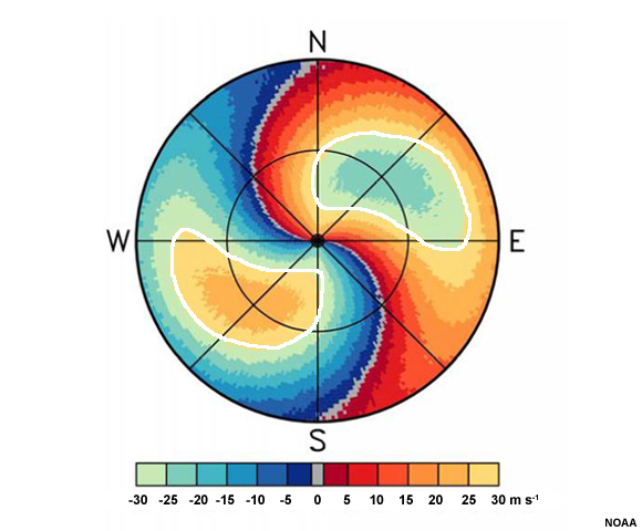
In some cases when very high wind speeds are present, such as when the radar samples strong jets or tropical cyclones, a radial velocity maximum or minimum will contain colors from the opposite wind direction in its center. Though one would normally conclude that the wind direction is somehow the opposite of the rest of the surrounding area and moving very fast, this is not correct. What we see here are in fact winds that change evenly from southerly at the surface to westerly at the edge of the radar's range that have a maximum speed at the level of the first range ring. The outlined areas in which the colors abruptly change to the opposite sign are a manifestation of the radar's maximum measurable velocity range. This phenomenon is known as aliasing or velocity folding.
Aliasing occurs when the radar's maximum unambiguous velocity is lower than the maximum velocity that is occurring. The maximum unambiguous velocity and maximum unambiguous range both depend on the pulse repetition frequency (PRF) but in opposite ways. This is a problem known as the "Doppler dilemma," in which a low PRF is desired for a large unambiguous range, but a high PRF is desired to observe high velocities.
When an environmental wind exceeds the maximum unambiguous velocity, the radar interprets it as a weaker wind of the opposite sign. The true environmental winds are offset by factors of 2*Vmax until they fall within the maximum unambiguous velocity range.
For example, if a radar's Vmax is 30 m s-1 and the environmental wind speed is 33 m s-1 away from the radar (positive and shaded in red-yellow), the radar will interpret this wind as being a 27 m s-1 inbound wind (negative and shaded in blue-green).
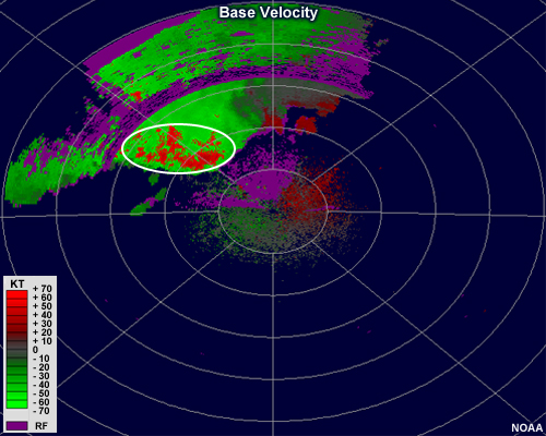
Here we have a thunderstorm complex containing strong winds. Some of the inbound winds are probably in excess of 70 kts. We can see aliasing where the red pixels are present within the large swath of strong green shades. Since there is no gradient or zero isodop present and the pixels abruptly change from red to green, aliasing is the likely cause.
Most NWS radars use some pattern of alternating high and low PRFs so that many of the aliased velocities and range-folded pixels can be removed or corrected by the software. Nonetheless, aliasing and range-folding remain complications to contend with, especially when using a shorter wavelength radar and in situations of very strong winds and wind shear, along boundaries, and in environments with significant clutter from non-meteorological targets.