Produced by The COMET® Program
Common Clear Air Phenomena » Meteorological Returns » Horizontal Convective Rolls
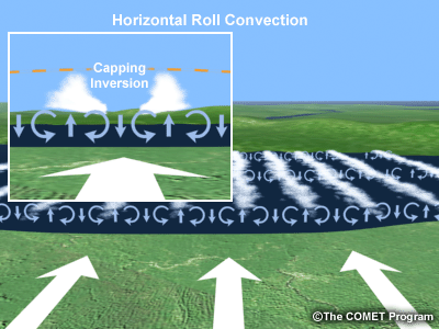
Horizontal convective rolls are counter-rotating horizontal circulations within the boundary layer and are often a precursor to convective development. They usually appear on radar on mostly clear days with strong surface heating and a fairly steady wind direction. Insects and other particulates act as tracers of the roll circulations before clouds form, and birds are often present in these areas to feed on the concentrated insects.
You will usually see a large area of scattered low reflectivity returns close to the radar. Often, you will be able to discern several distinct lines or areas of enhanced reflectivity. Commonly, you may notice these features on radar:
- Evenly scattered amount of weak echo near the radar location
- Several lines of enhanced reflectivity, often appearing as ripples
© Copyright 2012-2017, The University Corporation for Atmospheric Research.
All Rights Reserved. Legal Notices.