Tropical Cyclones » Structure on Radar
Tropical cyclones are easily recognized on radar. On reflectivity, they have three main noticeable features:
- The eye, which is a region that is nearly echo-free
- The eyewall, most often seen as a ring of high reflectivity surrounding the eye and frequently indicating some of the strongest convection in the system
- Spiral rainbands, which are narrow bands of intense rainfall that extend outward from the center of the storm
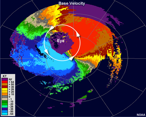
On velocity images, Northern Hemisphere tropical cyclones have a pattern that shows both their counterclockwise rotation and the speed maximum at low levels.
Here, we see that the radial velocity shows a symmetric pattern of counterclockwise flow, with the maximum wind speeds coinciding with the location of the eyewall. In the Northern Hemisphere, the velocities are slightly faster on the right-hand side with respect to the system's motion vector. This is because a tropical cyclone's forward motion and rotational motion are in the same direction on this side and add together. On the left-hand side, the rotational motion and forward motion are in opposing directions, resulting in lower speeds on that side.
Farther away from the radar, tropical cyclones often appear as a rotational couplet similar to that of a very large mesocyclone. Because of the very high wind speeds associated with tropical cyclones, aliasing may be present in some pixels of radial velocity images. In addition to this overall coupled appearance, storm-scale mesocyclones may be found within the stronger individual cells in some of the spiral rainbands.
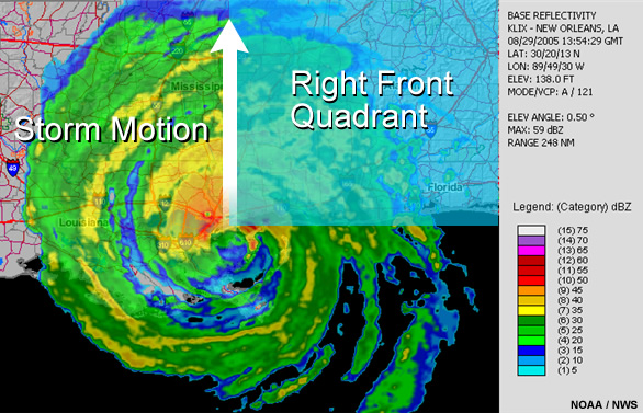
In the northern hemisphere, the occurrence of individual rotating cells is most common within the right front quadrant of hurricanes making landfall.
These cells can behave similarly to small supercells, and can produce weak to moderate tornadoes. It is often difficult to discern the small-scale rotation within individual cells in rainbands because of the already high velocities of the rotation of the hurricane itself. Aliasing may also cause some confusion. Rotational couplets in an environment like this may exhibit the usual inbound and outbound separation on either side of a radial drawn from the radar location and may contain some degree of convergence. In some cases, the couplet may appear more like a convergence signature than a rotational one.
To summarize, tropical cyclones on radar usually exhibit the following characteristics:
- Very low or no reflectivity within the eye
- An arc or ring of very high reflectivity in the location of the eyewall
- Additional narrow bands of high reflectivity emanating outward from the eyewall
- Storm-scale rotation within strong cells in the right front quadrant, especially within landfalling systems